You are here: Home > Network List > G - GEOSCOPE Stations List
> Station FOMA Nahampoana reservation, Fort Dauphin, Madagascar > Earthquake Result Viewer
FOMA Nahampoana reservation, Fort Dauphin, Madagascar - Earthquake Result Viewer

| Earthquake location: |
Northern Sumatra, Indonesia |
| Earthquake latitude/longitude: |
2.4/97.0 |
| Earthquake time(UTC): |
2010/04/06 (096) 22:15:01 GMT |
| Earthquake Depth: |
31 km |
| Earthquake Magnitude: |
7.0 MB, 7.9 MS, 7.8 MW, 7.7 MW |
| Earthquake Catalog/Contributor: |
WHDF/NEIC |
|
| Network: |
G GEOSCOPE |
| Station: |
FOMA Nahampoana reservation, Fort Dauphin, Madagascar |
| Lat/Lon: |
24.98 S/46.98 E |
| Elevation: |
26 m |
|
| Distance: |
55.6 deg |
| Az: |
237.486 deg |
| Baz: |
68.179 deg |
| Ray Param: |
0.06462146 |
| Estimated Moho Depth: |
36.25 km |
| Estimated Crust Vp/Vs: |
1.72 |
| Assumed Crust Vp: |
6.183 km/s |
| Estimated Crust Vs: |
3.605 km/s |
| Estimated Crust Poisson's Ratio: |
0.24 |
|
| Radial Match: |
98.335686 % |
| Radial Bump: |
227 |
| Transverse Match: |
93.30415 % |
| Transverse Bump: |
400 |
| SOD ConfigId: |
314316 |
| Insert Time: |
2010-07-27 06:37:08.536 +0000 |
| GWidth: |
2.5 |
| Max Bumps: |
400 |
| Tol: |
0.001 |
|
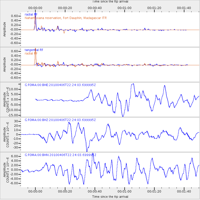
Signal To Noise
| Channel | StoN | STA | LTA |
| G:FOMA:00:BHZ:20100406T22:24:03.699995Z | 5.0858994 | 3.060128E-6 | 6.0168867E-7 |
| G:FOMA:00:BHN:20100406T22:24:03.699995Z | 1.1083301 | 3.813868E-7 | 3.441094E-7 |
| G:FOMA:00:BHE:20100406T22:24:03.699995Z | 3.0062912 | 1.2357356E-6 | 4.1104988E-7 |
| Arrivals |
| Ps | 4.4 SECOND |
| PpPs | 15 SECOND |
| PsPs/PpSs | 20 SECOND |


