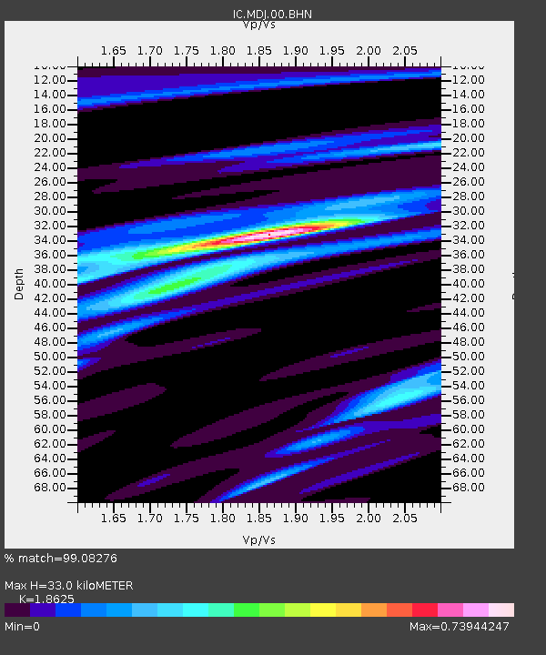
MDJ Mudanjiang, Heilongjiang Province, China - Earthquake Result Viewer

Earthquake location: Northern Sumatra, Indonesia
Earthquake latitude/longitude: 2.4/97.0
Earthquake time(UTC): 2010/04/06 (096) 22:15:01 GMT
Earthquake Depth: 31 km
Earthquake Magnitude: 7.0 MB, 7.9 MS, 7.8 MW, 7.7 MW
Earthquake Catalog/Contributor: WHDF/NEIC
Network: IC New China Digital Seismograph Network
Station: MDJ Mudanjiang, Heilongjiang Province, China
Lat/Lon: 44.62 N/129.59 E
Elevation: 250 m
Distance: 50.9 deg
Az: 29.665 deg
Baz: 223.822 deg
Ray Param: 0.06768445
Estimated Moho Depth: 33.0 km
Estimated Crust Vp/Vs: 1.86
Assumed Crust Vp: 6.459 km/s
Estimated Crust Vs: 3.468 km/s
Estimated Crust Poisson's Ratio: 0.30
Radial Match: 99.08276 %
Radial Bump: 201
Transverse Match: 92.41081 %
Transverse Bump: 400
SOD ConfigId: 314316
Insert Time: 2010-07-27 06:37:48.132 +0000
GWidth: 2.5
Max Bumps: 400
Tol: 0.001

Signal To Noise

ChannelStoNSTALTA
IC:MDJ:00:BHZ:20100406T22:23:29.211012Z17.8064929.722631E-65.460161E-7
IC:MDJ:00:BHN:20100406T22:23:29.211012Z11.8281663.0870199E-62.6098888E-7
IC:MDJ:00:BHE:20100406T22:23:29.211012Z13.6079833.6210038E-62.660941E-7
Arrivals
Ps4.7 SECOND
PpPs14 SECOND
PsPs/PpSs18 SECOND