You are here: Home > Network List > AV - Alaska Volcano Observatory Stations List
> Station SPCR Ckakachatna River, Mount Spurr, Alaska > Earthquake Result Viewer
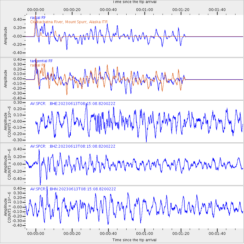
SPCR Ckakachatna River, Mount Spurr, Alaska - Earthquake Result Viewer
*The percent match for this event was below the threshold and hence no stack was calculated.
| Earthquake location: |
Eastern Kashmir |
| Earthquake latitude/longitude: |
33.1/75.9 |
| Earthquake time(UTC): |
2023/06/13 (164) 08:03:40 GMT |
| Earthquake Depth: |
10 km |
| Earthquake Magnitude: |
5.0 Mww |
| Earthquake Catalog/Contributor: |
NEIC PDE/us |
|
| Network: |
AV Alaska Volcano Observatory |
| Station: |
SPCR Ckakachatna River, Mount Spurr, Alaska |
| Lat/Lon: |
61.20 N/152.21 W |
| Elevation: |
984 m |
|
| Distance: |
78.2 deg |
| Az: |
21.605 deg |
| Baz: |
320.336 deg |
| Ray Param: |
$rayparam |
*The percent match for this event was below the threshold and hence was not used in the summary stack. |
|
| Radial Match: |
60.076904 % |
| Radial Bump: |
400 |
| Transverse Match: |
56.58705 % |
| Transverse Bump: |
380 |
| SOD ConfigId: |
30536071 |
| Insert Time: |
2023-06-27 08:11:23.423 +0000 |
| GWidth: |
2.5 |
| Max Bumps: |
400 |
| Tol: |
0.001 |
|
Signal To Noise
| Channel | StoN | STA | LTA |
| AV:SPCR: :BHZ:20230613T08:15:08.820022Z | 2.4590588 | 1.9381739E-7 | 7.881771E-8 |
| AV:SPCR: :BHN:20230613T08:15:08.820022Z | 1.5241494 | 1.5294329E-7 | 1.0034665E-7 |
| AV:SPCR: :BHE:20230613T08:15:08.820022Z | 1.1708417 | 1.2030632E-7 | 1.02752004E-7 |
| Arrivals |
| Ps | |
| PpPs | |
| PsPs/PpSs | |


