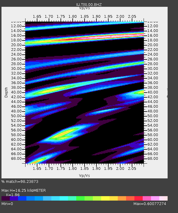
TIXI Tiksi, Russia - Earthquake Result Viewer
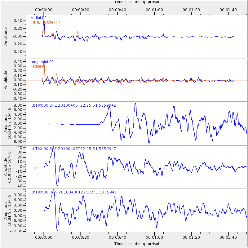
Earthquake location: Northern Sumatra, Indonesia
Earthquake latitude/longitude: 2.4/97.0
Earthquake time(UTC): 2010/04/06 (096) 22:15:01 GMT
Earthquake Depth: 31 km
Earthquake Magnitude: 7.0 MB, 7.9 MS, 7.8 MW, 7.7 MW
Earthquake Catalog/Contributor: WHDF/NEIC
Network: IU Global Seismograph Network (GSN - IRIS/USGS)
Station: TIXI Tiksi, Russia
Lat/Lon: 71.63 N/128.87 E
Elevation: 40 m
Distance: 72.0 deg
Az: 10.119 deg
Baz: 213.625 deg
Ray Param: 0.053878903
Estimated Moho Depth: 16.25 km
Estimated Crust Vp/Vs: 1.96
Assumed Crust Vp: 6.552 km/s
Estimated Crust Vs: 3.343 km/s
Estimated Crust Poisson's Ratio: 0.32
Radial Match: 98.23873 %
Radial Bump: 356
Transverse Match: 95.49046 %
Transverse Bump: 400
SOD ConfigId: 314316
Insert Time: 2010-07-27 06:38:22.747 +0000
GWidth: 2.5
Max Bumps: 400
Tol: 0.001

Signal To Noise

ChannelStoNSTALTA
IU:TIXI:00:BHZ:20100406T22:25:51.535994Z38.9417571.5379708E-53.949413E-7
IU:TIXI:00:BHN:20100406T22:25:51.535994Z29.7575554.6145997E-61.5507321E-7
IU:TIXI:00:BHE:20100406T22:25:51.535994Z25.883392.2841994E-68.8249614E-8
Arrivals
Ps2.5 SECOND
PpPs7.1 SECOND
PsPs/PpSs9.6 SECOND