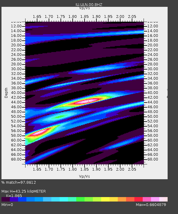
ULN Ulaanbaatar, Mongolia - Earthquake Result Viewer

Earthquake location: Northern Sumatra, Indonesia
Earthquake latitude/longitude: 2.4/97.0
Earthquake time(UTC): 2010/04/06 (096) 22:15:01 GMT
Earthquake Depth: 31 km
Earthquake Magnitude: 7.0 MB, 7.9 MS, 7.8 MW, 7.7 MW
Earthquake Catalog/Contributor: WHDF/NEIC
Network: IU Global Seismograph Network (GSN - IRIS/USGS)
Station: ULN Ulaanbaatar, Mongolia
Lat/Lon: 47.87 N/107.05 E
Elevation: 1610 m
Distance: 46.1 deg
Az: 9.34 deg
Baz: 193.934 deg
Ray Param: 0.070780665
Estimated Moho Depth: 43.25 km
Estimated Crust Vp/Vs: 1.87
Assumed Crust Vp: 6.642 km/s
Estimated Crust Vs: 3.561 km/s
Estimated Crust Poisson's Ratio: 0.30
Radial Match: 97.8612 %
Radial Bump: 236
Transverse Match: 82.48439 %
Transverse Bump: 400
SOD ConfigId: 314316
Insert Time: 2010-07-27 06:38:41.537 +0000
GWidth: 2.5
Max Bumps: 400
Tol: 0.001

Signal To Noise

ChannelStoNSTALTA
IU:ULN:00:BHZ:20100406T22:22:52.397993Z14.2184169.1285365E-66.4202203E-7
IU:ULN:00:BHN:20100406T22:22:52.397993Z9.4738044.19003E-64.4227528E-7
IU:ULN:00:BHE:20100406T22:22:52.397993Z12.5340451.5688872E-61.2517006E-7
Arrivals
Ps6.0 SECOND
PpPs17 SECOND
PsPs/PpSs24 SECOND