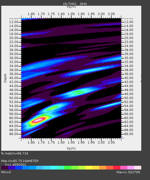
TKM2 KN.TKM2 - Earthquake Result Viewer
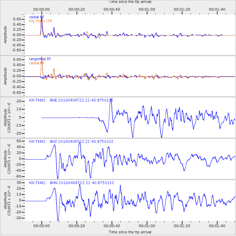
Earthquake location: Northern Sumatra, Indonesia
Earthquake latitude/longitude: 2.4/97.0
Earthquake time(UTC): 2010/04/06 (096) 22:15:01 GMT
Earthquake Depth: 31 km
Earthquake Magnitude: 7.0 MB, 7.9 MS, 7.8 MW, 7.7 MW
Earthquake Catalog/Contributor: WHDF/NEIC
Network: KN Kyrgyz Seismic Telemetry Network
Station: TKM2 KN.TKM2
Lat/Lon: 42.92 N/75.60 E
Elevation: 2020 m
Distance: 44.7 deg
Az: 337.536 deg
Baz: 148.686 deg
Ray Param: 0.071713924
Estimated Moho Depth: 60.75 km
Estimated Crust Vp/Vs: 1.69
Assumed Crust Vp: 6.306 km/s
Estimated Crust Vs: 3.742 km/s
Estimated Crust Poisson's Ratio: 0.23
Radial Match: 96.734 %
Radial Bump: 377
Transverse Match: 93.16219 %
Transverse Bump: 400
SOD ConfigId: 314316
Insert Time: 2010-07-27 06:39:45.492 +0000
GWidth: 2.5
Max Bumps: 400
Tol: 0.001

Signal To Noise

ChannelStoNSTALTA
KN:TKM2: :BHZ:20100406T22:22:40.875013Z32.728426.837424E-62.0891396E-7
KN:TKM2: :BHN:20100406T22:22:40.875013Z17.4518952.8015156E-61.6052788E-7
KN:TKM2: :BHE:20100406T22:22:40.875013Z21.7302072.2474478E-61.0342505E-7
Arrivals
Ps7.0 SECOND
PpPs24 SECOND
PsPs/PpSs31 SECOND