You are here: Home > Network List > AK - Alaska Regional Network Stations List
> Station CUT Chulitna, AK, USA > Earthquake Result Viewer
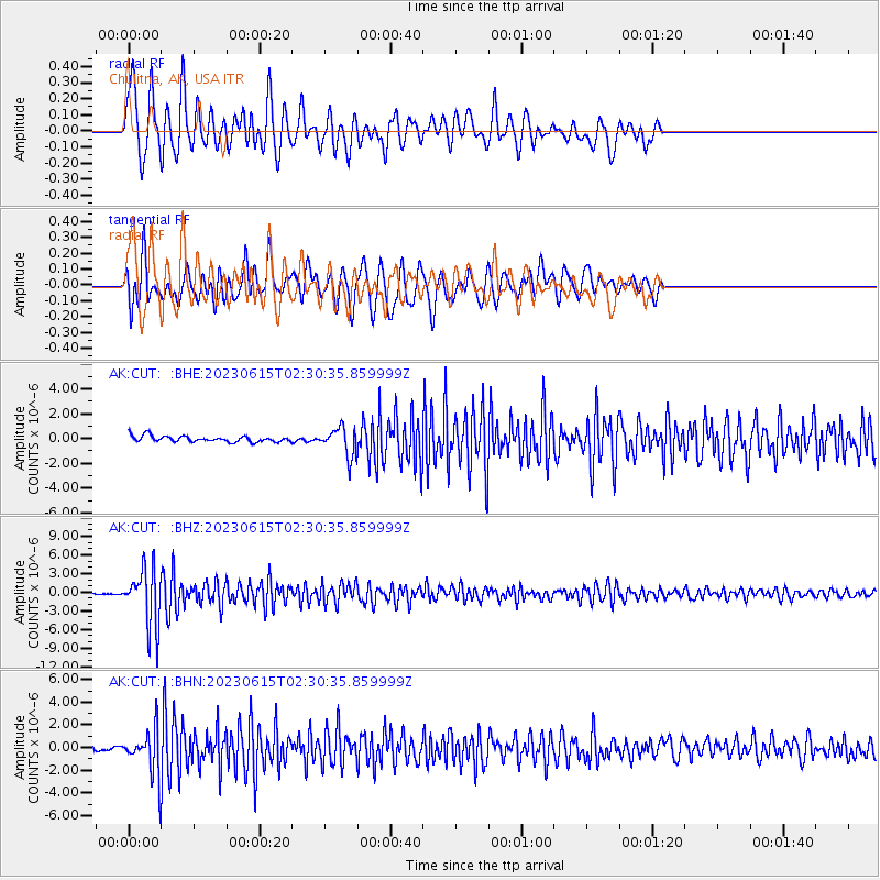
CUT Chulitna, AK, USA - Earthquake Result Viewer
| Earthquake location: |
Mindoro, Philippines |
| Earthquake latitude/longitude: |
13.8/120.7 |
| Earthquake time(UTC): |
2023/06/15 (166) 02:19:25 GMT |
| Earthquake Depth: |
124 km |
| Earthquake Magnitude: |
6.2 mww |
| Earthquake Catalog/Contributor: |
NEIC PDE/us |
|
| Network: |
AK Alaska Regional Network |
| Station: |
CUT Chulitna, AK, USA |
| Lat/Lon: |
62.41 N/150.26 W |
| Elevation: |
574 m |
|
| Distance: |
77.4 deg |
| Az: |
28.489 deg |
| Baz: |
275.626 deg |
| Ray Param: |
0.05003252 |
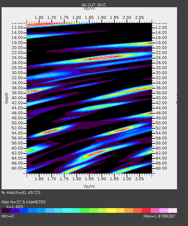
| Estimated Moho Depth: |
37.5 km |
| Estimated Crust Vp/Vs: |
1.61 |
| Assumed Crust Vp: |
6.438 km/s |
| Estimated Crust Vs: |
4.011 km/s |
| Estimated Crust Poisson's Ratio: |
0.18 |
|
| Radial Match: |
81.45723 % |
| Radial Bump: |
400 |
| Transverse Match: |
82.248764 % |
| Transverse Bump: |
400 |
| SOD ConfigId: |
30536071 |
| Insert Time: |
2023-06-29 02:22:21.058 +0000 |
| GWidth: |
2.5 |
| Max Bumps: |
400 |
| Tol: |
0.001 |
|
Signal To Noise
| Channel | StoN | STA | LTA |
| AK:CUT: :BHZ:20230615T02:30:35.859999Z | 68.23114 | 4.6036293E-6 | 6.7471085E-8 |
| AK:CUT: :BHN:20230615T02:30:35.859999Z | 9.682918 | 1.8459015E-6 | 1.9063485E-7 |
| AK:CUT: :BHE:20230615T02:30:35.859999Z | 4.56516 | 1.1079522E-6 | 2.4269738E-7 |
| Arrivals |
| Ps | 3.6 SECOND |
| PpPs | 15 SECOND |
| PsPs/PpSs | 18 SECOND |


