You are here: Home > Network List > AK - Alaska Regional Network Stations List
> Station O14K Tigyukauivet Mountain, AK, USA > Earthquake Result Viewer
O14K Tigyukauivet Mountain, AK, USA - Earthquake Result Viewer
| Earthquake location: |
Mindoro, Philippines |
| Earthquake latitude/longitude: |
13.8/120.7 |
| Earthquake time(UTC): |
2023/06/15 (166) 02:19:25 GMT |
| Earthquake Depth: |
124 km |
| Earthquake Magnitude: |
6.2 mww |
| Earthquake Catalog/Contributor: |
NEIC PDE/us |
|
| Network: |
AK Alaska Regional Network |
| Station: |
O14K Tigyukauivet Mountain, AK, USA |
| Lat/Lon: |
59.25 N/161.26 W |
| Elevation: |
129 m |
|
| Distance: |
72.1 deg |
| Az: |
31.875 deg |
| Baz: |
266.915 deg |
| Ray Param: |
0.053562935 |
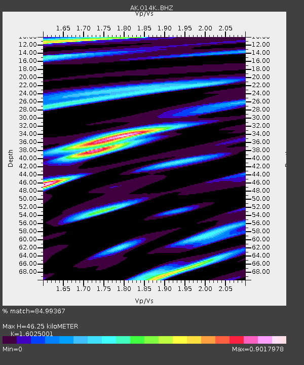
| Estimated Moho Depth: |
46.25 km |
| Estimated Crust Vp/Vs: |
1.60 |
| Assumed Crust Vp: |
6.24 km/s |
| Estimated Crust Vs: |
3.894 km/s |
| Estimated Crust Poisson's Ratio: |
0.18 |
|
| Radial Match: |
84.99367 % |
| Radial Bump: |
400 |
| Transverse Match: |
64.7581 % |
| Transverse Bump: |
400 |
| SOD ConfigId: |
30536071 |
| Insert Time: |
2023-06-29 02:24:21.152 +0000 |
| GWidth: |
2.5 |
| Max Bumps: |
400 |
| Tol: |
0.001 |
|

Signal To Noise
| Channel | StoN | STA | LTA |
| AK:O14K: :BHZ:20230615T02:30:05.359999Z | 23.125557 | 1.9110785E-6 | 8.263923E-8 |
| AK:O14K: :BHN:20230615T02:30:05.359999Z | 1.6002661 | 1.81096E-7 | 1.1316618E-7 |
| AK:O14K: :BHE:20230615T02:30:05.359999Z | 8.262119 | 6.253835E-7 | 7.569287E-8 |
| Arrivals |
| Ps | 4.6 SECOND |
| PpPs | 19 SECOND |
| PsPs/PpSs | 23 SECOND |


