You are here: Home > Network List > AK - Alaska Regional Network Stations List
> Station WRH Wood River Hill > Earthquake Result Viewer
WRH Wood River Hill - Earthquake Result Viewer
| Earthquake location: |
Mindoro, Philippines |
| Earthquake latitude/longitude: |
13.8/120.7 |
| Earthquake time(UTC): |
2023/06/15 (166) 02:19:25 GMT |
| Earthquake Depth: |
124 km |
| Earthquake Magnitude: |
6.2 mww |
| Earthquake Catalog/Contributor: |
NEIC PDE/us |
|
| Network: |
AK Alaska Regional Network |
| Station: |
WRH Wood River Hill |
| Lat/Lon: |
64.47 N/148.09 W |
| Elevation: |
343 m |
|
| Distance: |
78.2 deg |
| Az: |
26.27 deg |
| Baz: |
277.1 deg |
| Ray Param: |
0.049521323 |
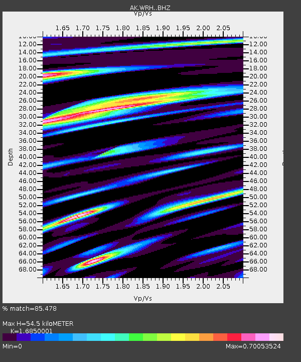
| Estimated Moho Depth: |
54.5 km |
| Estimated Crust Vp/Vs: |
1.69 |
| Assumed Crust Vp: |
6.566 km/s |
| Estimated Crust Vs: |
3.897 km/s |
| Estimated Crust Poisson's Ratio: |
0.23 |
|
| Radial Match: |
85.478 % |
| Radial Bump: |
400 |
| Transverse Match: |
74.24068 % |
| Transverse Bump: |
400 |
| SOD ConfigId: |
30536071 |
| Insert Time: |
2023-06-29 02:25:26.478 +0000 |
| GWidth: |
2.5 |
| Max Bumps: |
400 |
| Tol: |
0.001 |
|

Signal To Noise
| Channel | StoN | STA | LTA |
| AK:WRH: :BHZ:20230615T02:30:39.948012Z | 30.54926 | 1.9224638E-6 | 6.292996E-8 |
| AK:WRH: :BHN:20230615T02:30:39.948012Z | 4.037524 | 1.9909639E-7 | 4.9311506E-8 |
| AK:WRH: :BHE:20230615T02:30:39.948012Z | 7.9177623 | 4.2638274E-7 | 5.385142E-8 |
| Arrivals |
| Ps | 5.9 SECOND |
| PpPs | 22 SECOND |
| PsPs/PpSs | 27 SECOND |


