You are here: Home > Network List > AV - Alaska Volcano Observatory Stations List
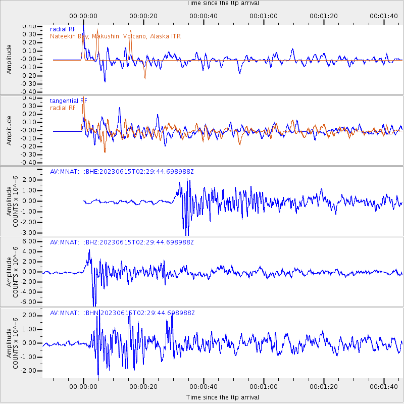
> Station MNAT Nateekin Bay, Makushin Volcano, Alaska > Earthquake Result Viewer
MNAT Nateekin Bay, Makushin Volcano, Alaska - Earthquake Result Viewer
| Earthquake location: |
Mindoro, Philippines |
| Earthquake latitude/longitude: |
13.8/120.7 |
| Earthquake time(UTC): |
2023/06/15 (166) 02:19:25 GMT |
| Earthquake Depth: |
124 km |
| Earthquake Magnitude: |
6.2 mww |
| Earthquake Catalog/Contributor: |
NEIC PDE/us |
|
| Network: |
AV Alaska Volcano Observatory |
| Station: |
MNAT Nateekin Bay, Makushin Volcano, Alaska |
| Lat/Lon: |
53.88 N/166.69 W |
| Elevation: |
390 m |
|
| Distance: |
68.7 deg |
| Az: |
37.321 deg |
| Baz: |
264.22 deg |
| Ray Param: |
0.055795092 |
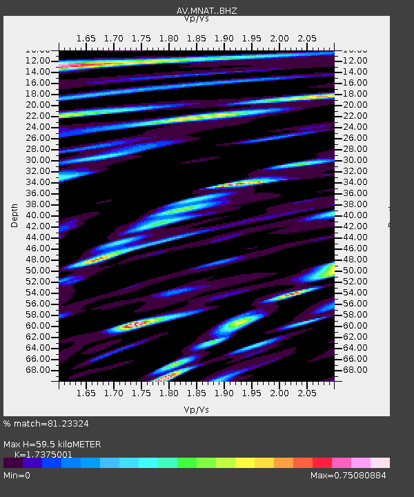
| Estimated Moho Depth: |
59.5 km |
| Estimated Crust Vp/Vs: |
1.74 |
| Assumed Crust Vp: |
3.943 km/s |
| Estimated Crust Vs: |
2.27 km/s |
| Estimated Crust Poisson's Ratio: |
0.25 |
|
| Radial Match: |
81.23324 % |
| Radial Bump: |
400 |
| Transverse Match: |
86.16101 % |
| Transverse Bump: |
400 |
| SOD ConfigId: |
30536071 |
| Insert Time: |
2023-06-29 02:28:51.219 +0000 |
| GWidth: |
2.5 |
| Max Bumps: |
400 |
| Tol: |
0.001 |
|
Signal To Noise
| Channel | StoN | STA | LTA |
| AV:MNAT: :BHZ:20230615T02:29:44.698988Z | 18.905434 | 2.6215428E-6 | 1.3866611E-7 |
| AV:MNAT: :BHN:20230615T02:29:44.698988Z | 6.895885 | 6.7047444E-7 | 9.7228195E-8 |
| AV:MNAT: :BHE:20230615T02:29:44.698988Z | 11.157183 | 1.2542276E-6 | 1.1241437E-7 |
| Arrivals |
| Ps | 11 SECOND |
| PpPs | 41 SECOND |
| PsPs/PpSs | 52 SECOND |


