You are here: Home > Network List > AV - Alaska Volcano Observatory Stations List
> Station N20K Mount Spurr, AK, USA > Earthquake Result Viewer
N20K Mount Spurr, AK, USA - Earthquake Result Viewer
| Earthquake location: |
Mindoro, Philippines |
| Earthquake latitude/longitude: |
13.8/120.7 |
| Earthquake time(UTC): |
2023/06/15 (166) 02:19:25 GMT |
| Earthquake Depth: |
124 km |
| Earthquake Magnitude: |
6.2 mww |
| Earthquake Catalog/Contributor: |
NEIC PDE/us |
|
| Network: |
AV Alaska Volcano Observatory |
| Station: |
N20K Mount Spurr, AK, USA |
| Lat/Lon: |
61.20 N/152.21 W |
| Elevation: |
991 m |
|
| Distance: |
76.6 deg |
| Az: |
29.808 deg |
| Baz: |
274.209 deg |
| Ray Param: |
0.05057243 |
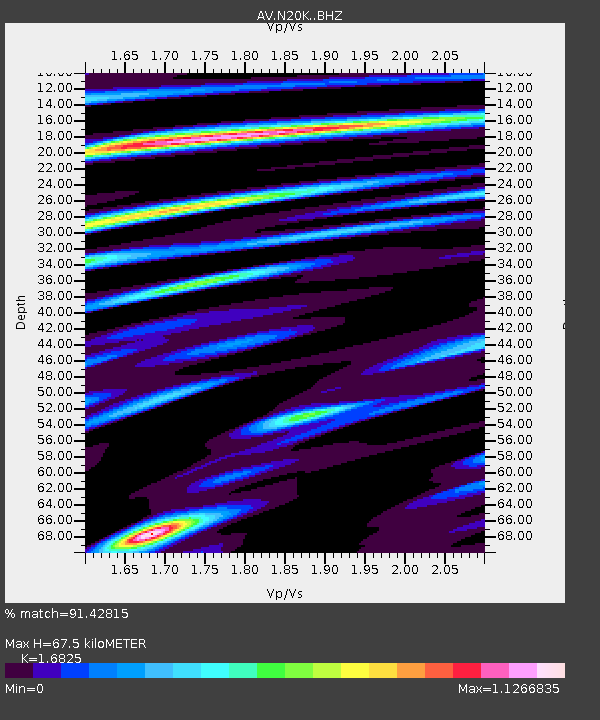
| Estimated Moho Depth: |
67.5 km |
| Estimated Crust Vp/Vs: |
1.68 |
| Assumed Crust Vp: |
6.566 km/s |
| Estimated Crust Vs: |
3.903 km/s |
| Estimated Crust Poisson's Ratio: |
0.23 |
|
| Radial Match: |
91.42815 % |
| Radial Bump: |
400 |
| Transverse Match: |
89.35503 % |
| Transverse Bump: |
400 |
| SOD ConfigId: |
30536071 |
| Insert Time: |
2023-06-29 02:28:57.669 +0000 |
| GWidth: |
2.5 |
| Max Bumps: |
400 |
| Tol: |
0.001 |
|

Signal To Noise
| Channel | StoN | STA | LTA |
| AV:N20K: :BHZ:20230615T02:30:31.325026Z | 39.57936 | 2.4854455E-6 | 6.279651E-8 |
| AV:N20K: :BHN:20230615T02:30:31.325026Z | 7.515635 | 4.1869987E-7 | 5.571051E-8 |
| AV:N20K: :BHE:20230615T02:30:31.325026Z | 13.3129835 | 7.020847E-7 | 5.273684E-8 |
| Arrivals |
| Ps | 7.3 SECOND |
| PpPs | 27 SECOND |
| PsPs/PpSs | 34 SECOND |


