You are here: Home > Network List > II - Global Seismograph Network (GSN - IRIS/IDA) Stations List
> Station AAK Ala Archa, Kyrgyzstan > Earthquake Result Viewer
AAK Ala Archa, Kyrgyzstan - Earthquake Result Viewer
| Earthquake location: |
Off W Coast Of Northern Sumatra |
| Earthquake latitude/longitude: |
3.5/95.8 |
| Earthquake time(UTC): |
2010/05/11 (131) 12:17:47 GMT |
| Earthquake Depth: |
40 km |
| Earthquake Magnitude: |
5.6 MB, 5.3 MS, 5.3 MW |
| Earthquake Catalog/Contributor: |
WHDF/NEIC |
|
| Network: |
II Global Seismograph Network (GSN - IRIS/IDA) |
| Station: |
AAK Ala Archa, Kyrgyzstan |
| Lat/Lon: |
42.64 N/74.49 E |
| Elevation: |
1645 m |
|
| Distance: |
43.4 deg |
| Az: |
336.971 deg |
| Baz: |
148.05 deg |
| Ray Param: |
0.07249731 |
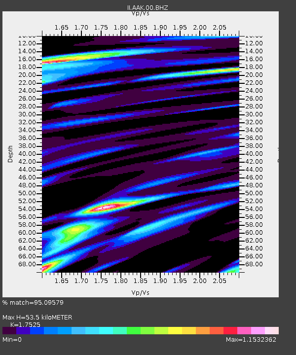
| Estimated Moho Depth: |
53.5 km |
| Estimated Crust Vp/Vs: |
1.75 |
| Assumed Crust Vp: |
6.306 km/s |
| Estimated Crust Vs: |
3.598 km/s |
| Estimated Crust Poisson's Ratio: |
0.26 |
|
| Radial Match: |
95.09579 % |
| Radial Bump: |
400 |
| Transverse Match: |
87.18439 % |
| Transverse Bump: |
400 |
| SOD ConfigId: |
314592 |
| Insert Time: |
2010-08-30 06:33:57.941 +0000 |
| GWidth: |
2.5 |
| Max Bumps: |
400 |
| Tol: |
0.001 |
|

Signal To Noise
| Channel | StoN | STA | LTA |
| II:AAK:00:BHZ:20100511T12:25:15.019991Z | 16.290815 | 6.428094E-7 | 3.9458396E-8 |
| II:AAK:00:BHN:20100511T12:25:15.019991Z | 15.074798 | 3.037412E-7 | 2.014894E-8 |
| II:AAK:00:BHE:20100511T12:25:15.019991Z | 9.90453 | 2.685647E-7 | 2.7115341E-8 |
| Arrivals |
| Ps | 6.8 SECOND |
| PpPs | 22 SECOND |
| PsPs/PpSs | 29 SECOND |


