You are here: Home > Network List > OX - North-East Italy Seismic Network Stations List
> Station CIMO Cimolais > Earthquake Result Viewer
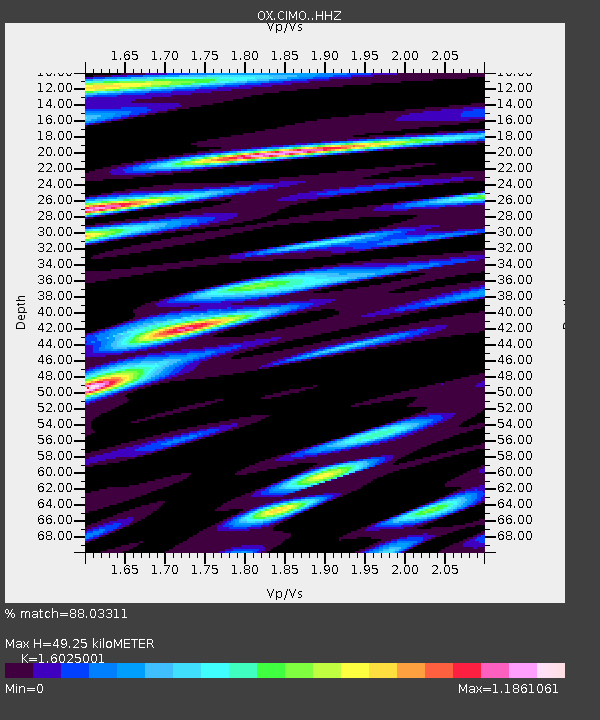
CIMO Cimolais - Earthquake Result Viewer
| Earthquake location: |
Mindoro, Philippines |
| Earthquake latitude/longitude: |
13.8/120.7 |
| Earthquake time(UTC): |
2023/06/15 (166) 02:19:25 GMT |
| Earthquake Depth: |
124 km |
| Earthquake Magnitude: |
6.2 mww |
| Earthquake Catalog/Contributor: |
NEIC PDE/us |
|
| Network: |
OX North-East Italy Seismic Network |
| Station: |
CIMO Cimolais |
| Lat/Lon: |
46.31 N/12.44 E |
| Elevation: |
710 m |
|
| Distance: |
92.3 deg |
| Az: |
318.795 deg |
| Baz: |
67.415 deg |
| Ray Param: |
0.041419115 |
| Estimated Moho Depth: |
49.25 km |
| Estimated Crust Vp/Vs: |
1.60 |
| Assumed Crust Vp: |
6.35 km/s |
| Estimated Crust Vs: |
3.963 km/s |
| Estimated Crust Poisson's Ratio: |
0.18 |
|
| Radial Match: |
88.03311 % |
| Radial Bump: |
400 |
| Transverse Match: |
83.25112 % |
| Transverse Bump: |
400 |
| SOD ConfigId: |
30536071 |
| Insert Time: |
2023-06-29 02:37:28.531 +0000 |
| GWidth: |
2.5 |
| Max Bumps: |
400 |
| Tol: |
0.001 |
|

Signal To Noise
| Channel | StoN | STA | LTA |
| OX:CIMO: :HHZ:20230615T02:31:50.159987Z | 33.689857 | 9.70029E-7 | 2.879291E-8 |
| OX:CIMO: :HHN:20230615T02:31:50.159987Z | 9.072145 | 2.815361E-7 | 3.1033025E-8 |
| OX:CIMO: :HHE:20230615T02:31:50.159987Z | 22.453701 | 4.4627743E-7 | 1.987545E-8 |
| Arrivals |
| Ps | 4.8 SECOND |
| PpPs | 20 SECOND |
| PsPs/PpSs | 25 SECOND |


