You are here: Home > Network List > 1E - GSC-BCOGC Induced Seismicity Study Stations List
> Station MONT9 Z > Earthquake Result Viewer
MONT9 Z - Earthquake Result Viewer
| Earthquake location: |
South Of Fiji Islands |
| Earthquake latitude/longitude: |
-22.9/-176.6 |
| Earthquake time(UTC): |
2023/06/15 (166) 18:06:29 GMT |
| Earthquake Depth: |
206 km |
| Earthquake Magnitude: |
7.0 Mi |
| Earthquake Catalog/Contributor: |
NEIC PDE/at |
|
| Network: |
1E GSC-BCOGC Induced Seismicity Study |
| Station: |
MONT9 Z |
| Lat/Lon: |
55.80 N/120.54 W |
| Elevation: |
832 m |
|
| Distance: |
91.6 deg |
| Az: |
27.944 deg |
| Baz: |
229.937 deg |
| Ray Param: |
0.041485615 |
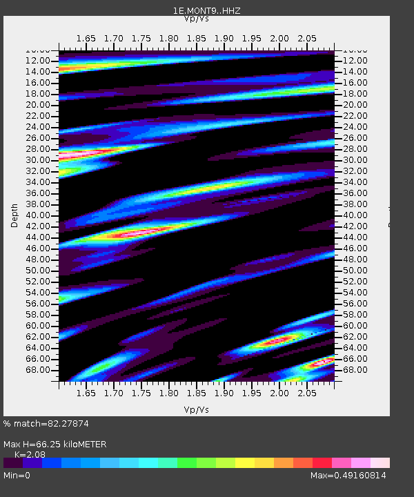
| Estimated Moho Depth: |
66.25 km |
| Estimated Crust Vp/Vs: |
2.08 |
| Assumed Crust Vp: |
6.303 km/s |
| Estimated Crust Vs: |
3.03 km/s |
| Estimated Crust Poisson's Ratio: |
0.35 |
|
| Radial Match: |
82.27874 % |
| Radial Bump: |
400 |
| Transverse Match: |
72.21647 % |
| Transverse Bump: |
400 |
| SOD ConfigId: |
30536071 |
| Insert Time: |
2023-06-29 18:08:58.468 +0000 |
| GWidth: |
2.5 |
| Max Bumps: |
400 |
| Tol: |
0.001 |
|

Signal To Noise
| Channel | StoN | STA | LTA |
| 1E:MONT9: :HHZ:20230615T18:18:41.250Z | 0.8570579 | 7.595914E-8 | 8.8627786E-8 |
| 1E:MONT9: :HHN:20230615T18:18:41.250Z | 0.96671283 | 6.0379625E-7 | 6.2458696E-7 |
| 1E:MONT9: :HHE:20230615T18:18:41.250Z | 1.1754291 | 2.6862477E-7 | 2.2853337E-7 |
| Arrivals |
| Ps | 12 SECOND |
| PpPs | 32 SECOND |
| PsPs/PpSs | 43 SECOND |


