You are here: Home > Network List > 1E - GSC-BCOGC Induced Seismicity Study Stations List
> Station MONTE Z > Earthquake Result Viewer
MONTE Z - Earthquake Result Viewer
| Earthquake location: |
South Of Fiji Islands |
| Earthquake latitude/longitude: |
-22.9/-176.6 |
| Earthquake time(UTC): |
2023/06/15 (166) 18:06:29 GMT |
| Earthquake Depth: |
206 km |
| Earthquake Magnitude: |
7.0 Mi |
| Earthquake Catalog/Contributor: |
NEIC PDE/at |
|
| Network: |
1E GSC-BCOGC Induced Seismicity Study |
| Station: |
MONTE Z |
| Lat/Lon: |
57.21 N/122.17 W |
| Elevation: |
0.0 m |
|
| Distance: |
91.9 deg |
| Az: |
26.281 deg |
| Baz: |
228.626 deg |
| Ray Param: |
0.041446052 |
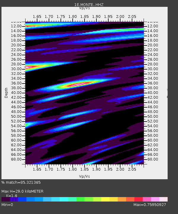
| Estimated Moho Depth: |
29.0 km |
| Estimated Crust Vp/Vs: |
1.60 |
| Assumed Crust Vp: |
6.232 km/s |
| Estimated Crust Vs: |
3.895 km/s |
| Estimated Crust Poisson's Ratio: |
0.18 |
|
| Radial Match: |
85.321365 % |
| Radial Bump: |
400 |
| Transverse Match: |
71.95711 % |
| Transverse Bump: |
400 |
| SOD ConfigId: |
30536071 |
| Insert Time: |
2023-06-29 18:09:02.568 +0000 |
| GWidth: |
2.5 |
| Max Bumps: |
400 |
| Tol: |
0.001 |
|

Signal To Noise
| Channel | StoN | STA | LTA |
| 1E:MONTE: :HHZ:20230615T18:18:42.330017Z | 1.6887531 | 1.5520713E-7 | 9.190635E-8 |
| 1E:MONTE: :HHN:20230615T18:18:42.330017Z | 1.2642255 | 8.561643E-7 | 6.7722436E-7 |
| 1E:MONTE: :HHE:20230615T18:18:42.330017Z | 1.05955 | 7.387617E-7 | 6.97241E-7 |
| Arrivals |
| Ps | 2.9 SECOND |
| PpPs | 12 SECOND |
| PsPs/PpSs | 15 SECOND |


