You are here: Home > Network List > AT - Alaska Tsunami Warning Seismic System Stations List
> Station SDPT Sand Point, Alaska > Earthquake Result Viewer
SDPT Sand Point, Alaska - Earthquake Result Viewer
| Earthquake location: |
South Of Fiji Islands |
| Earthquake latitude/longitude: |
-22.9/-176.6 |
| Earthquake time(UTC): |
2023/06/15 (166) 18:06:29 GMT |
| Earthquake Depth: |
206 km |
| Earthquake Magnitude: |
7.0 Mi |
| Earthquake Catalog/Contributor: |
NEIC PDE/at |
|
| Network: |
AT Alaska Tsunami Warning Seismic System |
| Station: |
SDPT Sand Point, Alaska |
| Lat/Lon: |
55.35 N/160.48 W |
| Elevation: |
74 m |
|
| Distance: |
79.1 deg |
| Az: |
9.294 deg |
| Baz: |
195.114 deg |
| Ray Param: |
0.04864854 |
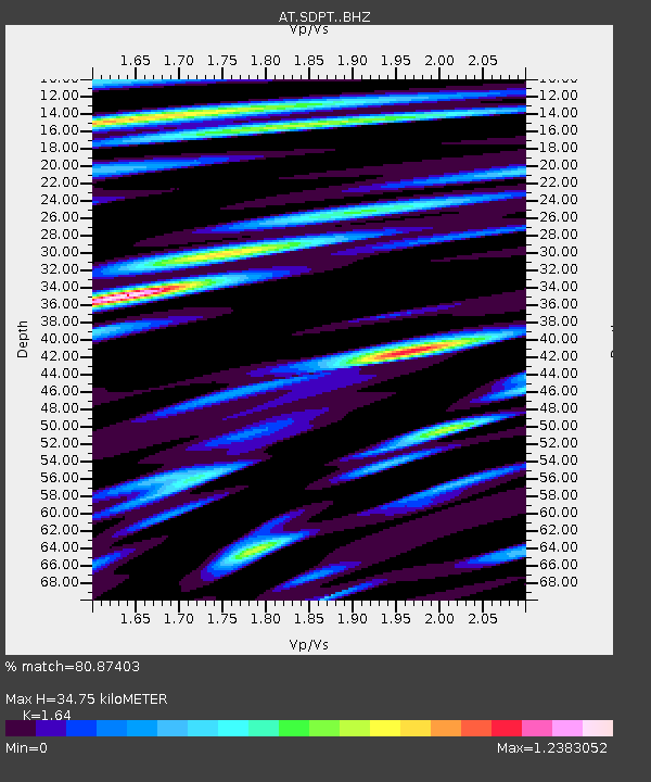
| Estimated Moho Depth: |
34.75 km |
| Estimated Crust Vp/Vs: |
1.64 |
| Assumed Crust Vp: |
5.989 km/s |
| Estimated Crust Vs: |
3.652 km/s |
| Estimated Crust Poisson's Ratio: |
0.20 |
|
| Radial Match: |
80.87403 % |
| Radial Bump: |
400 |
| Transverse Match: |
82.72228 % |
| Transverse Bump: |
400 |
| SOD ConfigId: |
30536071 |
| Insert Time: |
2023-06-29 18:11:40.082 +0000 |
| GWidth: |
2.5 |
| Max Bumps: |
400 |
| Tol: |
0.001 |
|

Signal To Noise
| Channel | StoN | STA | LTA |
| AT:SDPT: :BHZ:20230615T18:17:39.580017Z | 6.0009317 | 5.5914516E-6 | 9.317639E-7 |
| AT:SDPT: :BHN:20230615T18:17:39.580017Z | 1.114179 | 1.1767567E-6 | 1.0561648E-6 |
| AT:SDPT: :BHE:20230615T18:17:39.580017Z | 0.80287856 | 7.1823126E-7 | 8.9457023E-7 |
| Arrivals |
| Ps | 3.8 SECOND |
| PpPs | 15 SECOND |
| PsPs/PpSs | 19 SECOND |


