You are here: Home > Network List > AU - Australian Seismological Centre Stations List
> Station KLGGI Kalgoorlie Hampton Hill, WA, GSWA > Earthquake Result Viewer
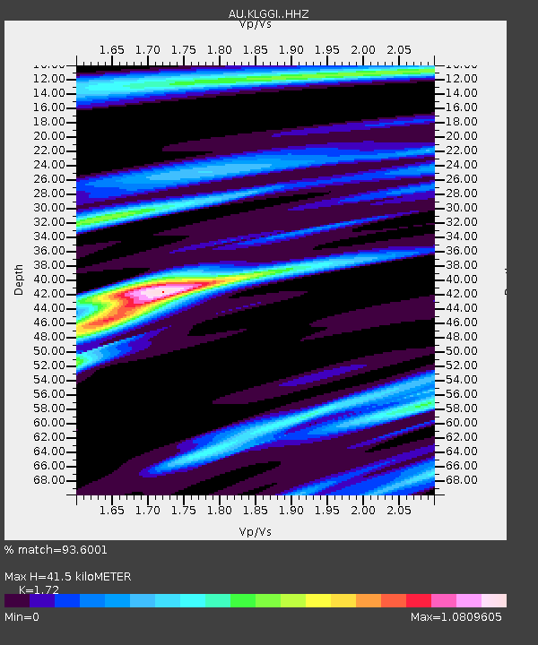
KLGGI Kalgoorlie Hampton Hill, WA, GSWA - Earthquake Result Viewer
| Earthquake location: |
South Of Fiji Islands |
| Earthquake latitude/longitude: |
-22.9/-176.6 |
| Earthquake time(UTC): |
2023/06/15 (166) 18:06:29 GMT |
| Earthquake Depth: |
206 km |
| Earthquake Magnitude: |
7.0 Mi |
| Earthquake Catalog/Contributor: |
NEIC PDE/at |
|
| Network: |
AU Australian Seismological Centre |
| Station: |
KLGGI Kalgoorlie Hampton Hill, WA, GSWA |
| Lat/Lon: |
30.28 S/121.76 E |
| Elevation: |
385 m |
|
| Distance: |
55.0 deg |
| Az: |
248.249 deg |
| Baz: |
98.06 deg |
| Ray Param: |
0.064359166 |
| Estimated Moho Depth: |
41.5 km |
| Estimated Crust Vp/Vs: |
1.72 |
| Assumed Crust Vp: |
6.459 km/s |
| Estimated Crust Vs: |
3.755 km/s |
| Estimated Crust Poisson's Ratio: |
0.24 |
|
| Radial Match: |
93.6001 % |
| Radial Bump: |
296 |
| Transverse Match: |
67.28344 % |
| Transverse Bump: |
371 |
| SOD ConfigId: |
30536071 |
| Insert Time: |
2023-06-29 18:12:12.463 +0000 |
| GWidth: |
2.5 |
| Max Bumps: |
400 |
| Tol: |
0.001 |
|

Signal To Noise
| Channel | StoN | STA | LTA |
| AU:KLGGI: :HHZ:20230615T18:15:08.47998Z | 9.681483 | 8.416453E-6 | 8.693351E-7 |
| AU:KLGGI: :HHN:20230615T18:15:08.47998Z | 1.5106759 | 1.0328006E-6 | 6.8366785E-7 |
| AU:KLGGI: :HHE:20230615T18:15:08.47998Z | 4.341186 | 4.8785496E-6 | 1.1237827E-6 |
| Arrivals |
| Ps | 4.9 SECOND |
| PpPs | 17 SECOND |
| PsPs/PpSs | 21 SECOND |


