You are here: Home > Network List > AV - Alaska Volcano Observatory Stations List
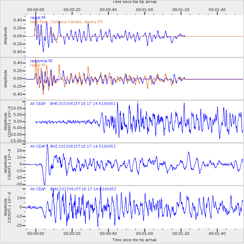
> Station CEAP Anvil Peak, Cerberus Volcano, Alaska > Earthquake Result Viewer
CEAP Anvil Peak, Cerberus Volcano, Alaska - Earthquake Result Viewer
| Earthquake location: |
South Of Fiji Islands |
| Earthquake latitude/longitude: |
-22.9/-176.6 |
| Earthquake time(UTC): |
2023/06/15 (166) 18:06:29 GMT |
| Earthquake Depth: |
206 km |
| Earthquake Magnitude: |
7.0 Mi |
| Earthquake Catalog/Contributor: |
NEIC PDE/at |
|
| Network: |
AV Alaska Volcano Observatory |
| Station: |
CEAP Anvil Peak, Cerberus Volcano, Alaska |
| Lat/Lon: |
52.00 N/179.58 E |
| Elevation: |
244 m |
|
| Distance: |
74.7 deg |
| Az: |
357.549 deg |
| Baz: |
176.343 deg |
| Ray Param: |
0.051655006 |
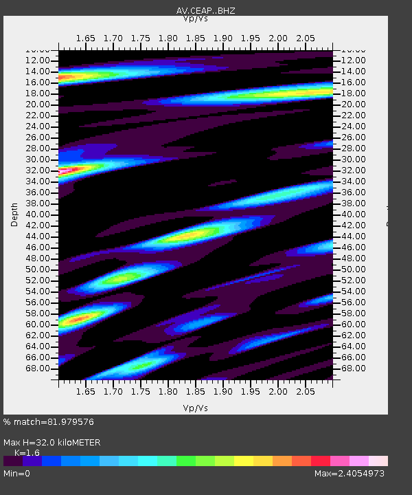
| Estimated Moho Depth: |
32.0 km |
| Estimated Crust Vp/Vs: |
1.60 |
| Assumed Crust Vp: |
6.183 km/s |
| Estimated Crust Vs: |
3.864 km/s |
| Estimated Crust Poisson's Ratio: |
0.18 |
|
| Radial Match: |
81.979576 % |
| Radial Bump: |
400 |
| Transverse Match: |
70.512695 % |
| Transverse Bump: |
400 |
| SOD ConfigId: |
30536071 |
| Insert Time: |
2023-06-29 18:13:28.815 +0000 |
| GWidth: |
2.5 |
| Max Bumps: |
400 |
| Tol: |
0.001 |
|
Signal To Noise
| Channel | StoN | STA | LTA |
| AV:CEAP: :BHZ:20230615T18:17:14.619995Z | 19.055418 | 9.095911E-6 | 4.773399E-7 |
| AV:CEAP: :BHN:20230615T18:17:14.619995Z | 3.5812054 | 2.8998322E-6 | 8.097364E-7 |
| AV:CEAP: :BHE:20230615T18:17:14.619995Z | 2.0933554 | 1.070485E-6 | 5.113728E-7 |
| Arrivals |
| Ps | 3.2 SECOND |
| PpPs | 13 SECOND |
| PsPs/PpSs | 16 SECOND |


