You are here: Home > Network List > AV - Alaska Volcano Observatory Stations List
> Station TAPA Point Aries, Tanaga Volcano, Alaska > Earthquake Result Viewer
TAPA Point Aries, Tanaga Volcano, Alaska - Earthquake Result Viewer
| Earthquake location: |
South Of Fiji Islands |
| Earthquake latitude/longitude: |
-22.9/-176.6 |
| Earthquake time(UTC): |
2023/06/15 (166) 18:06:29 GMT |
| Earthquake Depth: |
206 km |
| Earthquake Magnitude: |
7.0 Mi |
| Earthquake Catalog/Contributor: |
NEIC PDE/at |
|
| Network: |
AV Alaska Volcano Observatory |
| Station: |
TAPA Point Aries, Tanaga Volcano, Alaska |
| Lat/Lon: |
51.81 N/177.81 W |
| Elevation: |
640 m |
|
| Distance: |
74.4 deg |
| Az: |
359.217 deg |
| Baz: |
178.837 deg |
| Ray Param: |
0.051818054 |
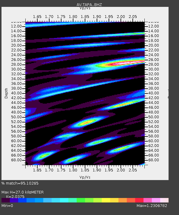
| Estimated Moho Depth: |
27.0 km |
| Estimated Crust Vp/Vs: |
2.04 |
| Assumed Crust Vp: |
5.88 km/s |
| Estimated Crust Vs: |
2.886 km/s |
| Estimated Crust Poisson's Ratio: |
0.34 |
|
| Radial Match: |
95.10265 % |
| Radial Bump: |
400 |
| Transverse Match: |
85.36926 % |
| Transverse Bump: |
400 |
| SOD ConfigId: |
30536071 |
| Insert Time: |
2023-06-29 18:15:31.343 +0000 |
| GWidth: |
2.5 |
| Max Bumps: |
400 |
| Tol: |
0.001 |
|

Signal To Noise
| Channel | StoN | STA | LTA |
| AV:TAPA: :BHZ:20230615T18:17:13.158997Z | 24.848085 | 9.5923115E-6 | 3.8603824E-7 |
| AV:TAPA: :BHN:20230615T18:17:13.158997Z | 3.8365984 | 2.633886E-6 | 6.8651593E-7 |
| AV:TAPA: :BHE:20230615T18:17:13.158997Z | 0.77363455 | 1.3968862E-6 | 1.8056152E-6 |
| Arrivals |
| Ps | 4.9 SECOND |
| PpPs | 14 SECOND |
| PsPs/PpSs | 19 SECOND |


