You are here: Home > Network List > CC - Cascade Chain Volcano Monitoring Stations List
> Station HUSB The Husband > Earthquake Result Viewer
HUSB The Husband - Earthquake Result Viewer
| Earthquake location: |
South Of Fiji Islands |
| Earthquake latitude/longitude: |
-22.9/-176.6 |
| Earthquake time(UTC): |
2023/06/15 (166) 18:06:29 GMT |
| Earthquake Depth: |
206 km |
| Earthquake Magnitude: |
7.0 Mi |
| Earthquake Catalog/Contributor: |
NEIC PDE/at |
|
| Network: |
CC Cascade Chain Volcano Monitoring |
| Station: |
HUSB The Husband |
| Lat/Lon: |
44.12 N/121.85 W |
| Elevation: |
2038 m |
|
| Distance: |
83.4 deg |
| Az: |
36.305 deg |
| Baz: |
229.294 deg |
| Ray Param: |
0.0457139 |
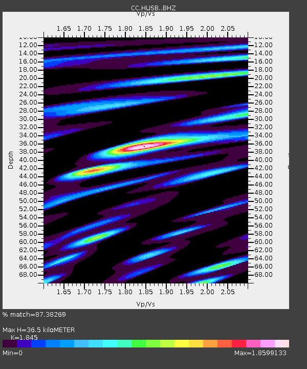
| Estimated Moho Depth: |
36.5 km |
| Estimated Crust Vp/Vs: |
1.85 |
| Assumed Crust Vp: |
6.597 km/s |
| Estimated Crust Vs: |
3.576 km/s |
| Estimated Crust Poisson's Ratio: |
0.29 |
|
| Radial Match: |
87.38269 % |
| Radial Bump: |
400 |
| Transverse Match: |
79.572014 % |
| Transverse Bump: |
400 |
| SOD ConfigId: |
30536071 |
| Insert Time: |
2023-06-29 18:17:36.301 +0000 |
| GWidth: |
2.5 |
| Max Bumps: |
400 |
| Tol: |
0.001 |
|

Signal To Noise
| Channel | StoN | STA | LTA |
| CC:HUSB: :BHZ:20230615T18:18:01.880005Z | 2.160615 | 3.7793606E-7 | 1.749206E-7 |
| CC:HUSB: :BHN:20230615T18:18:01.880005Z | 1.4228873 | 1.0303146E-6 | 7.241013E-7 |
| CC:HUSB: :BHE:20230615T18:18:01.880005Z | 1.509664 | 6.979697E-7 | 4.6233447E-7 |
| Arrivals |
| Ps | 4.8 SECOND |
| PpPs | 15 SECOND |
| PsPs/PpSs | 20 SECOND |


