You are here: Home > Network List > G - GEOSCOPE Stations List
> Station DRV Dumont d'Urville, Terre Adelie (Antartica) > Earthquake Result Viewer
DRV Dumont d'Urville, Terre Adelie (Antartica) - Earthquake Result Viewer
| Earthquake location: |
South Of Fiji Islands |
| Earthquake latitude/longitude: |
-22.9/-176.6 |
| Earthquake time(UTC): |
2023/06/15 (166) 18:06:29 GMT |
| Earthquake Depth: |
206 km |
| Earthquake Magnitude: |
7.0 Mi |
| Earthquake Catalog/Contributor: |
NEIC PDE/at |
|
| Network: |
G GEOSCOPE |
| Station: |
DRV Dumont d'Urville, Terre Adelie (Antartica) |
| Lat/Lon: |
66.67 S/140.01 E |
| Elevation: |
40 m |
|
| Distance: |
51.6 deg |
| Az: |
200.452 deg |
| Baz: |
53.984 deg |
| Ray Param: |
0.06659977 |
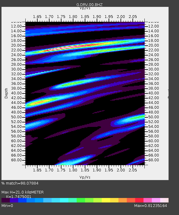
| Estimated Moho Depth: |
21.0 km |
| Estimated Crust Vp/Vs: |
1.75 |
| Assumed Crust Vp: |
6.39 km/s |
| Estimated Crust Vs: |
3.657 km/s |
| Estimated Crust Poisson's Ratio: |
0.26 |
|
| Radial Match: |
98.07884 % |
| Radial Bump: |
315 |
| Transverse Match: |
95.0708 % |
| Transverse Bump: |
400 |
| SOD ConfigId: |
30536071 |
| Insert Time: |
2023-06-29 18:20:40.807 +0000 |
| GWidth: |
2.5 |
| Max Bumps: |
400 |
| Tol: |
0.001 |
|
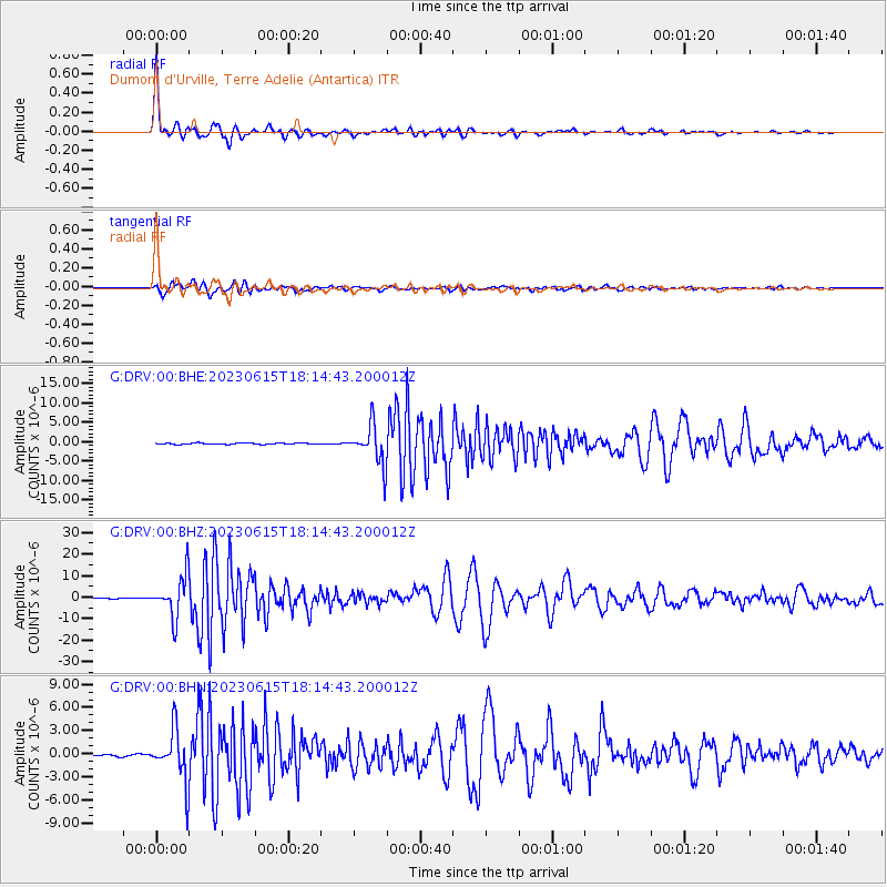
Signal To Noise
| Channel | StoN | STA | LTA |
| G:DRV:00:BHZ:20230615T18:14:43.200012Z | 60.70703 | 9.597678E-6 | 1.580983E-7 |
| G:DRV:00:BHN:20230615T18:14:43.200012Z | 23.363747 | 3.330976E-6 | 1.4257029E-7 |
| G:DRV:00:BHE:20230615T18:14:43.200012Z | 33.071026 | 4.986688E-6 | 1.5078722E-7 |
| Arrivals |
| Ps | 2.6 SECOND |
| PpPs | 8.5 SECOND |
| PsPs/PpSs | 11 SECOND |


