You are here: Home > Network List > O2 - Oklahoma Consolidated Temporary Seismic Networks Stations List
> Station GORE Near Medford, Oklahoma, USA > Earthquake Result Viewer
GORE Near Medford, Oklahoma, USA - Earthquake Result Viewer
| Earthquake location: |
South Of Fiji Islands |
| Earthquake latitude/longitude: |
-22.9/-176.6 |
| Earthquake time(UTC): |
2023/06/15 (166) 18:06:29 GMT |
| Earthquake Depth: |
206 km |
| Earthquake Magnitude: |
7.0 Mi |
| Earthquake Catalog/Contributor: |
NEIC PDE/at |
|
| Network: |
O2 Oklahoma Consolidated Temporary Seismic Networks |
| Station: |
GORE Near Medford, Oklahoma, USA |
| Lat/Lon: |
36.79 N/97.95 W |
| Elevation: |
348 m |
|
| Distance: |
94.9 deg |
| Az: |
52.183 deg |
| Baz: |
245.146 deg |
| Ray Param: |
0.04077692 |
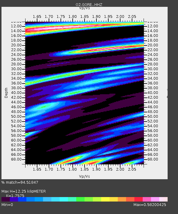
| Estimated Moho Depth: |
12.25 km |
| Estimated Crust Vp/Vs: |
1.76 |
| Assumed Crust Vp: |
6.483 km/s |
| Estimated Crust Vs: |
3.689 km/s |
| Estimated Crust Poisson's Ratio: |
0.26 |
|
| Radial Match: |
94.51847 % |
| Radial Bump: |
362 |
| Transverse Match: |
78.06274 % |
| Transverse Bump: |
400 |
| SOD ConfigId: |
30536071 |
| Insert Time: |
2023-06-29 18:24:50.691 +0000 |
| GWidth: |
2.5 |
| Max Bumps: |
400 |
| Tol: |
0.001 |
|

Signal To Noise
| Channel | StoN | STA | LTA |
| O2:GORE: :HHZ:20230615T18:18:56.025024Z | 0.77464586 | 7.6835484E-8 | 9.918788E-8 |
| O2:GORE: :HHN:20230615T18:18:56.025024Z | 2.378327 | 2.0628563E-7 | 8.6735604E-8 |
| O2:GORE: :HHE:20230615T18:18:56.025024Z | 1.5116574 | 1.4783265E-7 | 9.779508E-8 |
| Arrivals |
| Ps | 1.5 SECOND |
| PpPs | 5.1 SECOND |
| PsPs/PpSs | 6.6 SECOND |


