You are here: Home > Network List > PS - Pacific21 Stations List
> Station JAY Jayapura, Indonesia > Earthquake Result Viewer
JAY Jayapura, Indonesia - Earthquake Result Viewer
| Earthquake location: |
South Of Fiji Islands |
| Earthquake latitude/longitude: |
-22.9/-176.6 |
| Earthquake time(UTC): |
2023/06/15 (166) 18:06:29 GMT |
| Earthquake Depth: |
206 km |
| Earthquake Magnitude: |
7.0 Mi |
| Earthquake Catalog/Contributor: |
NEIC PDE/at |
|
| Network: |
PS Pacific21 |
| Station: |
JAY Jayapura, Indonesia |
| Lat/Lon: |
2.51 S/140.70 E |
| Elevation: |
439 m |
|
| Distance: |
46.1 deg |
| Az: |
289.8 deg |
| Baz: |
119.723 deg |
| Ray Param: |
0.07009841 |
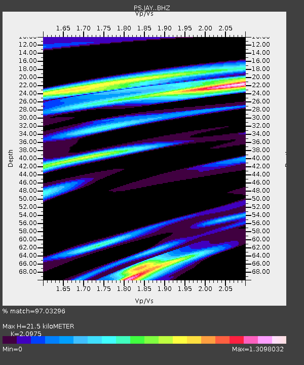
| Estimated Moho Depth: |
21.5 km |
| Estimated Crust Vp/Vs: |
2.10 |
| Assumed Crust Vp: |
6.461 km/s |
| Estimated Crust Vs: |
3.081 km/s |
| Estimated Crust Poisson's Ratio: |
0.35 |
|
| Radial Match: |
97.03296 % |
| Radial Bump: |
286 |
| Transverse Match: |
86.947365 % |
| Transverse Bump: |
400 |
| SOD ConfigId: |
30536071 |
| Insert Time: |
2023-06-29 18:26:36.733 +0000 |
| GWidth: |
2.5 |
| Max Bumps: |
400 |
| Tol: |
0.001 |
|

Signal To Noise
| Channel | StoN | STA | LTA |
| PS:JAY: :BHZ:20230615T18:14:01.561005Z | 43.069725 | 1.01328815E-5 | 2.3526692E-7 |
| PS:JAY: :BHN:20230615T18:14:01.561005Z | 41.10253 | 4.7436015E-6 | 1.1540898E-7 |
| PS:JAY: :BHE:20230615T18:14:01.561005Z | 39.85001 | 5.5424894E-6 | 1.3908375E-7 |
| Arrivals |
| Ps | 3.8 SECOND |
| PpPs | 9.8 SECOND |
| PsPs/PpSs | 14 SECOND |


