You are here: Home > Network List > RV - Regional Alberta Seismic Observatory for Earthquake Studies Network Stations List
> Station STPRA Salt Prairie Lookout Tower, AB > Earthquake Result Viewer
STPRA Salt Prairie Lookout Tower, AB - Earthquake Result Viewer
| Earthquake location: |
South Of Fiji Islands |
| Earthquake latitude/longitude: |
-22.9/-176.6 |
| Earthquake time(UTC): |
2023/06/15 (166) 18:06:29 GMT |
| Earthquake Depth: |
206 km |
| Earthquake Magnitude: |
7.0 Mi |
| Earthquake Catalog/Contributor: |
NEIC PDE/at |
|
| Network: |
RV Regional Alberta Seismic Observatory for Earthquake Studies Network |
| Station: |
STPRA Salt Prairie Lookout Tower, AB |
| Lat/Lon: |
55.66 N/115.83 W |
| Elevation: |
761 m |
|
| Distance: |
93.6 deg |
| Az: |
29.704 deg |
| Baz: |
233.737 deg |
| Ray Param: |
0.04108331 |
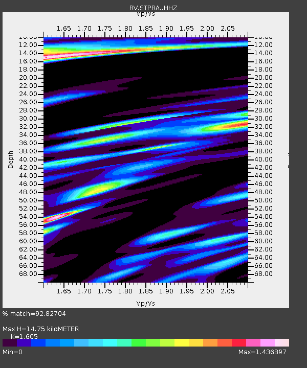
| Estimated Moho Depth: |
14.75 km |
| Estimated Crust Vp/Vs: |
1.61 |
| Assumed Crust Vp: |
6.483 km/s |
| Estimated Crust Vs: |
4.039 km/s |
| Estimated Crust Poisson's Ratio: |
0.18 |
|
| Radial Match: |
92.82704 % |
| Radial Bump: |
400 |
| Transverse Match: |
72.666115 % |
| Transverse Bump: |
400 |
| SOD ConfigId: |
30536071 |
| Insert Time: |
2023-06-29 18:27:25.293 +0000 |
| GWidth: |
2.5 |
| Max Bumps: |
400 |
| Tol: |
0.001 |
|

Signal To Noise
| Channel | StoN | STA | LTA |
| RV:STPRA: :HHZ:20230615T18:18:50.440002Z | 1.1698884 | 8.7630376E-8 | 7.4904904E-8 |
| RV:STPRA: :HHN:20230615T18:18:50.440002Z | 0.70708233 | 3.0053457E-7 | 4.2503476E-7 |
| RV:STPRA: :HHE:20230615T18:18:50.440002Z | 1.4337052 | 2.7462372E-7 | 1.9154825E-7 |
| Arrivals |
| Ps | 1.4 SECOND |
| PpPs | 5.8 SECOND |
| PsPs/PpSs | 7.2 SECOND |


