You are here: Home > Network List > S1 - Australian Seismometers in Schools Stations List
> Station AUBRN Burnie High School > Earthquake Result Viewer
AUBRN Burnie High School - Earthquake Result Viewer
| Earthquake location: |
South Of Fiji Islands |
| Earthquake latitude/longitude: |
-22.9/-176.6 |
| Earthquake time(UTC): |
2023/06/15 (166) 18:06:29 GMT |
| Earthquake Depth: |
206 km |
| Earthquake Magnitude: |
7.0 Mi |
| Earthquake Catalog/Contributor: |
NEIC PDE/at |
|
| Network: |
S1 Australian Seismometers in Schools |
| Station: |
AUBRN Burnie High School |
| Lat/Lon: |
41.04 S/145.87 E |
| Elevation: |
10 m |
|
| Distance: |
36.3 deg |
| Az: |
231.159 deg |
| Baz: |
71.714 deg |
| Ray Param: |
0.0760149 |
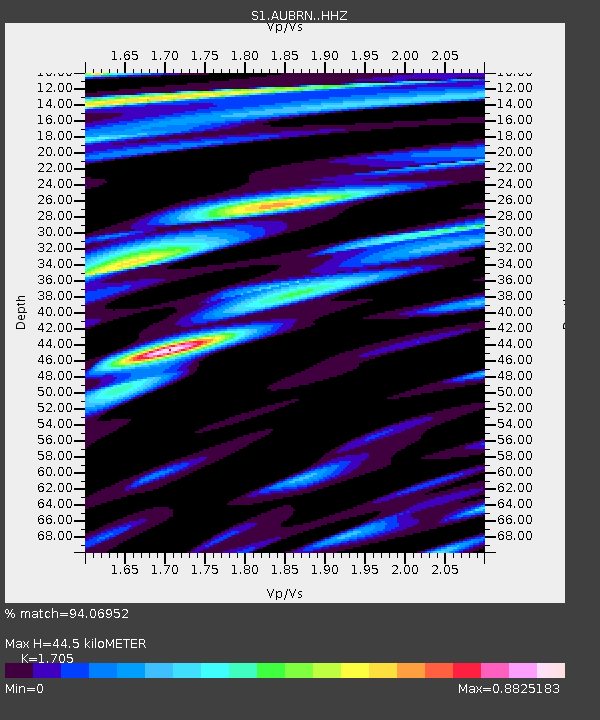
| Estimated Moho Depth: |
44.5 km |
| Estimated Crust Vp/Vs: |
1.71 |
| Assumed Crust Vp: |
6.477 km/s |
| Estimated Crust Vs: |
3.799 km/s |
| Estimated Crust Poisson's Ratio: |
0.24 |
|
| Radial Match: |
94.06952 % |
| Radial Bump: |
396 |
| Transverse Match: |
88.54236 % |
| Transverse Bump: |
400 |
| SOD ConfigId: |
30536071 |
| Insert Time: |
2023-06-29 18:27:40.619 +0000 |
| GWidth: |
2.5 |
| Max Bumps: |
400 |
| Tol: |
0.001 |
|

Signal To Noise
| Channel | StoN | STA | LTA |
| S1:AUBRN: :HHZ:20230615T18:12:42.070007Z | 11.957933 | 7.726719E-6 | 6.4615836E-7 |
| S1:AUBRN: :HHN:20230615T18:12:42.070007Z | 5.4931374 | 3.1857364E-6 | 5.7994845E-7 |
| S1:AUBRN: :HHE:20230615T18:12:42.070007Z | 5.570487 | 3.5767541E-6 | 6.4209E-7 |
| Arrivals |
| Ps | 5.2 SECOND |
| PpPs | 17 SECOND |
| PsPs/PpSs | 22 SECOND |


