You are here: Home > Network List > US - United States National Seismic Network Stations List
> Station AMTX Amarillo, Texas, USA > Earthquake Result Viewer
AMTX Amarillo, Texas, USA - Earthquake Result Viewer
| Earthquake location: |
South Of Fiji Islands |
| Earthquake latitude/longitude: |
-22.9/-176.6 |
| Earthquake time(UTC): |
2023/06/15 (166) 18:06:29 GMT |
| Earthquake Depth: |
206 km |
| Earthquake Magnitude: |
7.0 Mi |
| Earthquake Catalog/Contributor: |
NEIC PDE/at |
|
| Network: |
US United States National Seismic Network |
| Station: |
AMTX Amarillo, Texas, USA |
| Lat/Lon: |
34.53 N/101.41 W |
| Elevation: |
1010 m |
|
| Distance: |
91.4 deg |
| Az: |
52.978 deg |
| Baz: |
243.093 deg |
| Ray Param: |
0.041530266 |
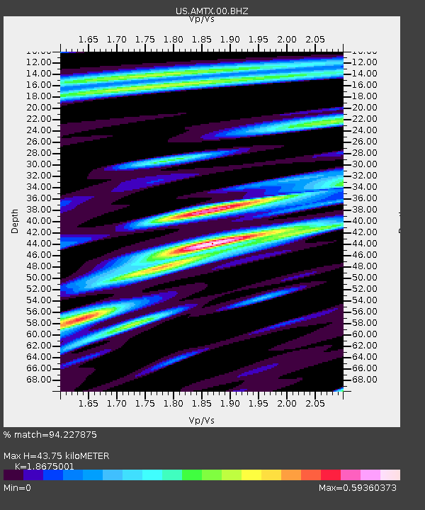
| Estimated Moho Depth: |
43.75 km |
| Estimated Crust Vp/Vs: |
1.87 |
| Assumed Crust Vp: |
6.426 km/s |
| Estimated Crust Vs: |
3.441 km/s |
| Estimated Crust Poisson's Ratio: |
0.30 |
|
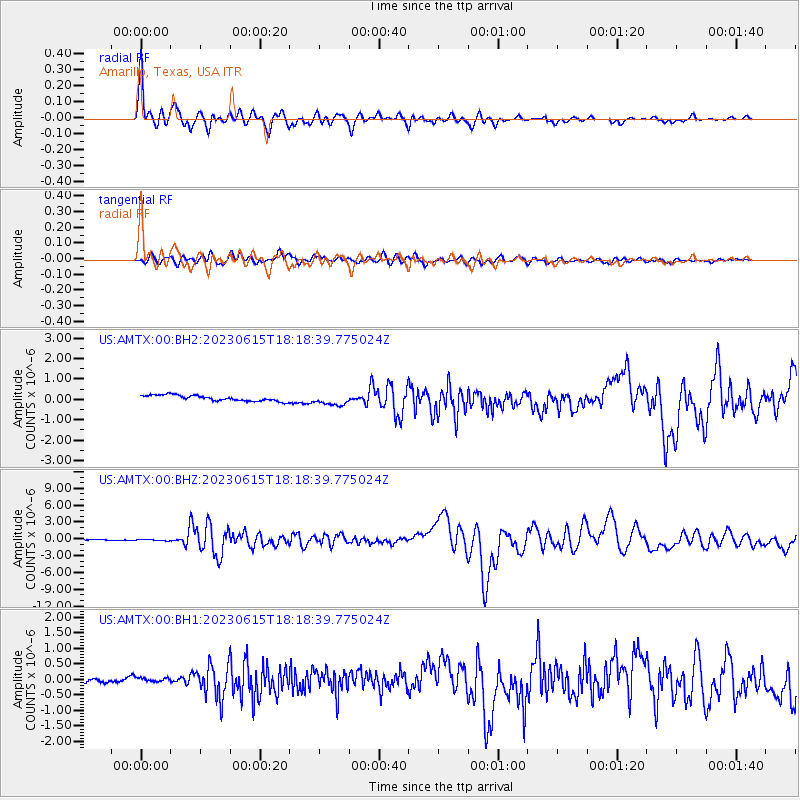
| Radial Match: |
94.227875 % |
| Radial Bump: |
400 |
| Transverse Match: |
80.27601 % |
| Transverse Bump: |
400 |
| SOD ConfigId: |
30536071 |
| Insert Time: |
2023-06-29 18:31:26.069 +0000 |
| GWidth: |
2.5 |
| Max Bumps: |
400 |
| Tol: |
0.001 |
|
Signal To Noise
| Channel | StoN | STA | LTA |
| US:AMTX:00:BHZ:20230615T18:18:39.775024Z | 1.0454513 | 1.0766553E-7 | 1.02984735E-7 |
| US:AMTX:00:BH1:20230615T18:18:39.775024Z | 0.865703 | 8.324717E-8 | 9.616136E-8 |
| US:AMTX:00:BH2:20230615T18:18:39.775024Z | 1.976253 | 2.8066364E-7 | 1.4201807E-7 |
| Arrivals |
| Ps | 6.0 SECOND |
| PpPs | 19 SECOND |
| PsPs/PpSs | 25 SECOND |


