You are here: Home > Network List > WW - Idaho Seismic Network () Stations List
> Station TYLR Tyler Ranch Idaho > Earthquake Result Viewer
TYLR Tyler Ranch Idaho - Earthquake Result Viewer
| Earthquake location: |
South Of Fiji Islands |
| Earthquake latitude/longitude: |
-22.9/-176.6 |
| Earthquake time(UTC): |
2023/06/15 (166) 18:06:29 GMT |
| Earthquake Depth: |
206 km |
| Earthquake Magnitude: |
7.0 Mi |
| Earthquake Catalog/Contributor: |
NEIC PDE/at |
|
| Network: |
WW Idaho Seismic Network () |
| Station: |
TYLR Tyler Ranch Idaho |
| Lat/Lon: |
45.10 N/114.85 W |
| Elevation: |
1203 m |
|
| Distance: |
87.9 deg |
| Az: |
38.628 deg |
| Baz: |
234.37 deg |
| Ray Param: |
0.04247516 |
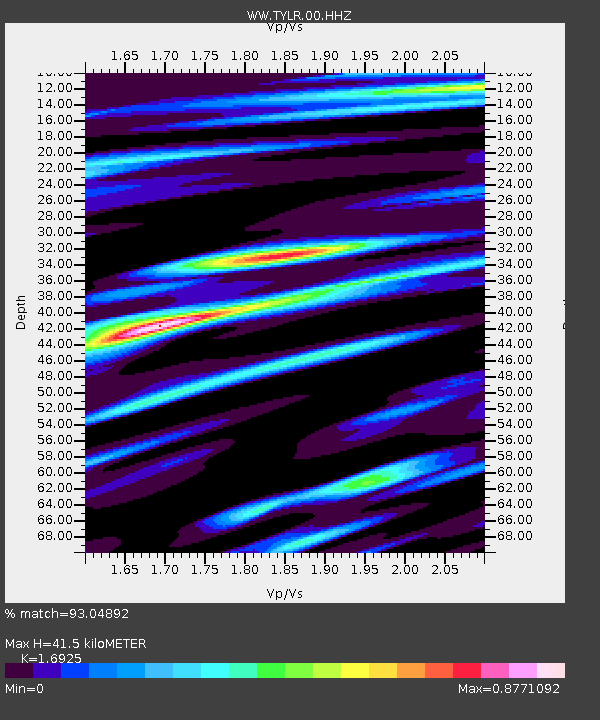
| Estimated Moho Depth: |
41.5 km |
| Estimated Crust Vp/Vs: |
1.69 |
| Assumed Crust Vp: |
6.577 km/s |
| Estimated Crust Vs: |
3.886 km/s |
| Estimated Crust Poisson's Ratio: |
0.23 |
|
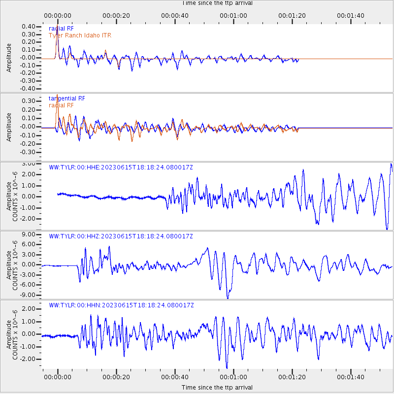
| Radial Match: |
93.04892 % |
| Radial Bump: |
400 |
| Transverse Match: |
92.81485 % |
| Transverse Bump: |
400 |
| SOD ConfigId: |
30536071 |
| Insert Time: |
2023-06-29 18:33:49.211 +0000 |
| GWidth: |
2.5 |
| Max Bumps: |
400 |
| Tol: |
0.001 |
|
Signal To Noise
| Channel | StoN | STA | LTA |
| WW:TYLR:00:HHZ:20230615T18:18:24.080017Z | 0.7010723 | 3.5710375E-8 | 5.0936794E-8 |
| WW:TYLR:00:HHN:20230615T18:18:24.080017Z | 0.92169344 | 2.280887E-7 | 2.4746697E-7 |
| WW:TYLR:00:HHE:20230615T18:18:24.080017Z | 0.869874 | 1.16774046E-7 | 1.3424248E-7 |
| Arrivals |
| Ps | 4.5 SECOND |
| PpPs | 17 SECOND |
| PsPs/PpSs | 21 SECOND |


