You are here: Home > Network List > AK - Alaska Regional Network Stations List
> Station PNL Peninsula > Earthquake Result Viewer
PNL Peninsula - Earthquake Result Viewer
| Earthquake location: |
South Of Fiji Islands |
| Earthquake latitude/longitude: |
-23.0/-177.2 |
| Earthquake time(UTC): |
2023/06/15 (166) 18:06:27 GMT |
| Earthquake Depth: |
167 km |
| Earthquake Magnitude: |
7.2 Mww |
| Earthquake Catalog/Contributor: |
NEIC PDE/us |
|
| Network: |
AK Alaska Regional Network |
| Station: |
PNL Peninsula |
| Lat/Lon: |
59.67 N/139.40 W |
| Elevation: |
596 m |
|
| Distance: |
88.0 deg |
| Az: |
18.139 deg |
| Baz: |
214.422 deg |
| Ray Param: |
0.04253756 |
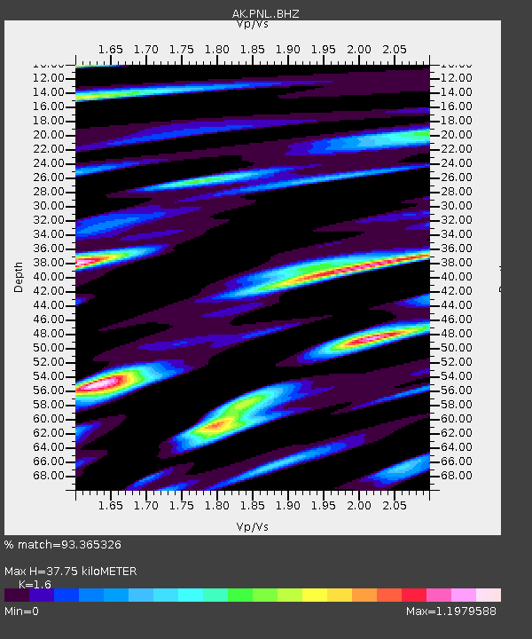
| Estimated Moho Depth: |
37.75 km |
| Estimated Crust Vp/Vs: |
1.60 |
| Assumed Crust Vp: |
6.183 km/s |
| Estimated Crust Vs: |
3.864 km/s |
| Estimated Crust Poisson's Ratio: |
0.18 |
|
| Radial Match: |
93.365326 % |
| Radial Bump: |
400 |
| Transverse Match: |
91.60297 % |
| Transverse Bump: |
400 |
| SOD ConfigId: |
30536071 |
| Insert Time: |
2023-06-29 18:38:23.489 +0000 |
| GWidth: |
2.5 |
| Max Bumps: |
400 |
| Tol: |
0.001 |
|

Signal To Noise
| Channel | StoN | STA | LTA |
| AK:PNL: :BHZ:20230615T18:18:27.627975Z | 65.081436 | 1.1468042E-5 | 1.7621066E-7 |
| AK:PNL: :BHN:20230615T18:18:27.627975Z | 12.561121 | 3.0676604E-6 | 2.4421868E-7 |
| AK:PNL: :BHE:20230615T18:18:27.627975Z | 13.397551 | 3.323502E-6 | 2.4806786E-7 |
| Arrivals |
| Ps | 3.7 SECOND |
| PpPs | 16 SECOND |
| PsPs/PpSs | 19 SECOND |


