You are here: Home > Network List > AV - Alaska Volcano Observatory Stations List
> Station CERA Ragged Top, Cerberus Volcano, Alaska > Earthquake Result Viewer
CERA Ragged Top, Cerberus Volcano, Alaska - Earthquake Result Viewer
| Earthquake location: |
South Of Fiji Islands |
| Earthquake latitude/longitude: |
-23.0/-177.2 |
| Earthquake time(UTC): |
2023/06/15 (166) 18:06:27 GMT |
| Earthquake Depth: |
167 km |
| Earthquake Magnitude: |
7.2 Mww |
| Earthquake Catalog/Contributor: |
NEIC PDE/us |
|
| Network: |
AV Alaska Volcano Observatory |
| Station: |
CERA Ragged Top, Cerberus Volcano, Alaska |
| Lat/Lon: |
51.91 N/179.68 E |
| Elevation: |
305 m |
|
| Distance: |
74.6 deg |
| Az: |
358.002 deg |
| Baz: |
177.028 deg |
| Ray Param: |
0.051790807 |
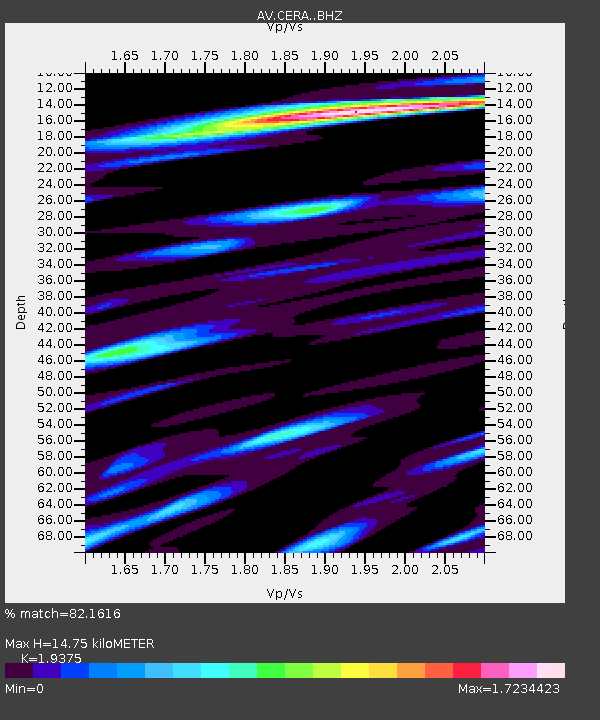
| Estimated Moho Depth: |
14.75 km |
| Estimated Crust Vp/Vs: |
1.94 |
| Assumed Crust Vp: |
6.183 km/s |
| Estimated Crust Vs: |
3.191 km/s |
| Estimated Crust Poisson's Ratio: |
0.32 |
|
| Radial Match: |
82.1616 % |
| Radial Bump: |
400 |
| Transverse Match: |
78.464386 % |
| Transverse Bump: |
400 |
| SOD ConfigId: |
30536071 |
| Insert Time: |
2023-06-29 18:41:27.849 +0000 |
| GWidth: |
2.5 |
| Max Bumps: |
400 |
| Tol: |
0.001 |
|

Signal To Noise
| Channel | StoN | STA | LTA |
| AV:CERA: :BHZ:20230615T18:17:17.540023Z | 45.230507 | 1.6888098E-5 | 3.733785E-7 |
| AV:CERA: :BHN:20230615T18:17:17.540023Z | 14.896818 | 9.170463E-6 | 6.1559876E-7 |
| AV:CERA: :BHE:20230615T18:17:17.540023Z | 7.0946546 | 5.8445526E-6 | 8.237966E-7 |
| Arrivals |
| Ps | 2.3 SECOND |
| PpPs | 6.8 SECOND |
| PsPs/PpSs | 9.1 SECOND |


