You are here: Home > Network List > AV - Alaska Volcano Observatory Stations List
> Station CESW Southwest, Cerberus Volcano, Alaska > Earthquake Result Viewer
CESW Southwest, Cerberus Volcano, Alaska - Earthquake Result Viewer
| Earthquake location: |
South Of Fiji Islands |
| Earthquake latitude/longitude: |
-23.0/-177.2 |
| Earthquake time(UTC): |
2023/06/15 (166) 18:06:27 GMT |
| Earthquake Depth: |
167 km |
| Earthquake Magnitude: |
7.2 Mww |
| Earthquake Catalog/Contributor: |
NEIC PDE/us |
|
| Network: |
AV Alaska Volcano Observatory |
| Station: |
CESW Southwest, Cerberus Volcano, Alaska |
| Lat/Lon: |
51.90 N/179.56 E |
| Elevation: |
238 m |
|
| Distance: |
74.6 deg |
| Az: |
357.924 deg |
| Baz: |
176.912 deg |
| Ray Param: |
0.051792163 |
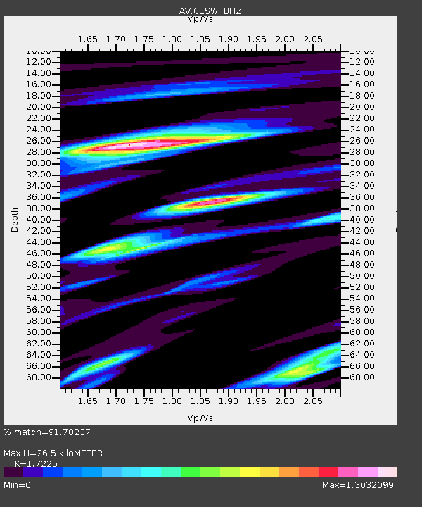
| Estimated Moho Depth: |
26.5 km |
| Estimated Crust Vp/Vs: |
1.72 |
| Assumed Crust Vp: |
6.183 km/s |
| Estimated Crust Vs: |
3.589 km/s |
| Estimated Crust Poisson's Ratio: |
0.25 |
|
| Radial Match: |
91.78237 % |
| Radial Bump: |
400 |
| Transverse Match: |
90.00065 % |
| Transverse Bump: |
400 |
| SOD ConfigId: |
30536071 |
| Insert Time: |
2023-06-29 18:41:31.063 +0000 |
| GWidth: |
2.5 |
| Max Bumps: |
400 |
| Tol: |
0.001 |
|

Signal To Noise
| Channel | StoN | STA | LTA |
| AV:CESW: :BHZ:20230615T18:17:17.538986Z | 54.406204 | 1.6389282E-5 | 3.0123923E-7 |
| AV:CESW: :BHN:20230615T18:17:17.538986Z | 18.938795 | 8.786011E-6 | 4.6391602E-7 |
| AV:CESW: :BHE:20230615T18:17:17.538986Z | 9.024817 | 3.3858787E-6 | 3.7517418E-7 |
| Arrivals |
| Ps | 3.2 SECOND |
| PpPs | 11 SECOND |
| PsPs/PpSs | 15 SECOND |


