You are here: Home > Network List > AV - Alaska Volcano Observatory Stations List
> Station GSTR Teapot Rock, Great Sitkin Volcano, Alaska > Earthquake Result Viewer
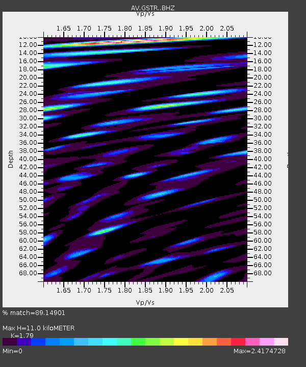
GSTR Teapot Rock, Great Sitkin Volcano, Alaska - Earthquake Result Viewer
| Earthquake location: |
South Of Fiji Islands |
| Earthquake latitude/longitude: |
-23.0/-177.2 |
| Earthquake time(UTC): |
2023/06/15 (166) 18:06:27 GMT |
| Earthquake Depth: |
167 km |
| Earthquake Magnitude: |
7.2 Mww |
| Earthquake Catalog/Contributor: |
NEIC PDE/us |
|
| Network: |
AV Alaska Volcano Observatory |
| Station: |
GSTR Teapot Rock, Great Sitkin Volcano, Alaska |
| Lat/Lon: |
52.09 N/176.06 W |
| Elevation: |
536 m |
|
| Distance: |
74.8 deg |
| Az: |
0.733 deg |
| Baz: |
181.095 deg |
| Ray Param: |
0.051700037 |
| Estimated Moho Depth: |
11.0 km |
| Estimated Crust Vp/Vs: |
1.79 |
| Assumed Crust Vp: |
3.912 km/s |
| Estimated Crust Vs: |
2.185 km/s |
| Estimated Crust Poisson's Ratio: |
0.27 |
|
| Radial Match: |
89.14901 % |
| Radial Bump: |
400 |
| Transverse Match: |
92.36513 % |
| Transverse Bump: |
400 |
| SOD ConfigId: |
30536071 |
| Insert Time: |
2023-06-29 18:41:54.914 +0000 |
| GWidth: |
2.5 |
| Max Bumps: |
400 |
| Tol: |
0.001 |
|

Signal To Noise
| Channel | StoN | STA | LTA |
| AV:GSTR: :BHZ:20230615T18:17:18.379989Z | 54.415447 | 3.513389E-5 | 6.456602E-7 |
| AV:GSTR: :BHN:20230615T18:17:18.379989Z | 6.231709 | 1.4348491E-5 | 2.302497E-6 |
| AV:GSTR: :BHE:20230615T18:17:18.379989Z | 10.002777 | 1.1840709E-5 | 1.1837421E-6 |
| Arrivals |
| Ps | 2.2 SECOND |
| PpPs | 7.8 SECOND |
| PsPs/PpSs | 10 SECOND |


