You are here: Home > Network List > AV - Alaska Volcano Observatory Stations List
> Station MAPS Pakushin Southeast, Makushin Volcano, Alaska > Earthquake Result Viewer
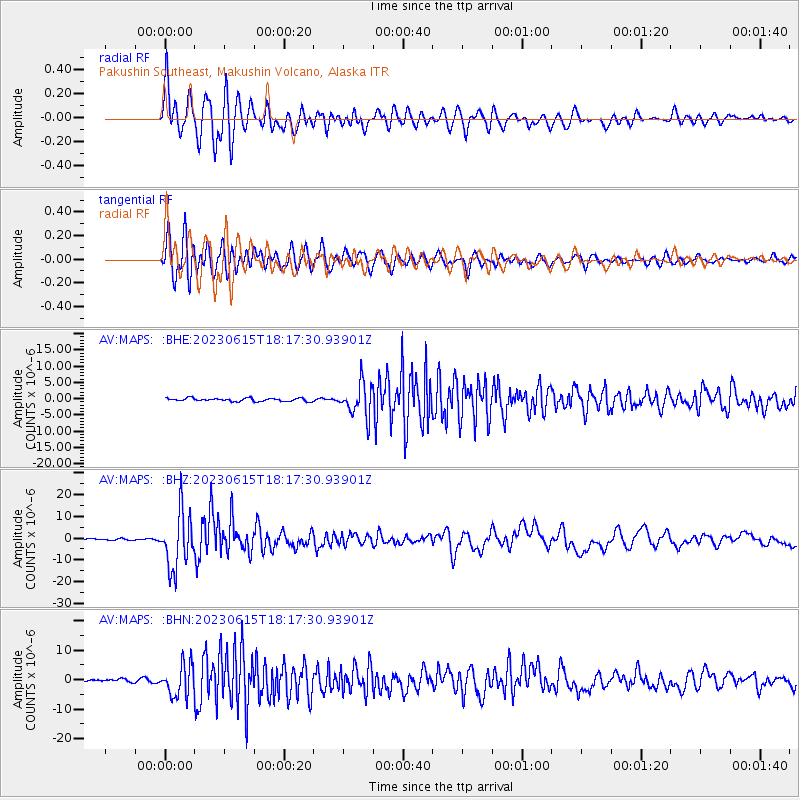
MAPS Pakushin Southeast, Makushin Volcano, Alaska - Earthquake Result Viewer
*The percent match for this event was below the threshold and hence no stack was calculated.
| Earthquake location: |
South Of Fiji Islands |
| Earthquake latitude/longitude: |
-23.0/-177.2 |
| Earthquake time(UTC): |
2023/06/15 (166) 18:06:27 GMT |
| Earthquake Depth: |
167 km |
| Earthquake Magnitude: |
7.2 Mww |
| Earthquake Catalog/Contributor: |
NEIC PDE/us |
|
| Network: |
AV Alaska Volcano Observatory |
| Station: |
MAPS Pakushin Southeast, Makushin Volcano, Alaska |
| Lat/Lon: |
53.81 N/166.94 W |
| Elevation: |
333 m |
|
| Distance: |
77.0 deg |
| Az: |
6.228 deg |
| Baz: |
189.705 deg |
| Ray Param: |
$rayparam |
*The percent match for this event was below the threshold and hence was not used in the summary stack. |
|
| Radial Match: |
90.505646 % |
| Radial Bump: |
400 |
| Transverse Match: |
72.570435 % |
| Transverse Bump: |
400 |
| SOD ConfigId: |
30536071 |
| Insert Time: |
2023-06-29 18:42:48.128 +0000 |
| GWidth: |
2.5 |
| Max Bumps: |
400 |
| Tol: |
0.001 |
|
Signal To Noise
| Channel | StoN | STA | LTA |
| AV:MAPS: :BHZ:20230615T18:17:30.93901Z | 30.196712 | 1.2829876E-5 | 4.248766E-7 |
| AV:MAPS: :BHN:20230615T18:17:30.93901Z | 12.521186 | 5.58321E-6 | 4.459011E-7 |
| AV:MAPS: :BHE:20230615T18:17:30.93901Z | 10.317383 | 5.00539E-6 | 4.8514147E-7 |
| Arrivals |
| Ps | |
| PpPs | |
| PsPs/PpSs | |


