You are here: Home > Network List > AV - Alaska Volcano Observatory Stations List
> Station MGLS Mageik Landslide, Katmai, Volcanic Group, Alaska > Earthquake Result Viewer
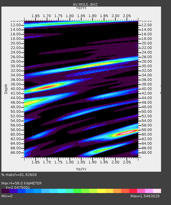
MGLS Mageik Landslide, Katmai, Volcanic Group, Alaska - Earthquake Result Viewer
| Earthquake location: |
South Of Fiji Islands |
| Earthquake latitude/longitude: |
-23.0/-177.2 |
| Earthquake time(UTC): |
2023/06/15 (166) 18:06:27 GMT |
| Earthquake Depth: |
167 km |
| Earthquake Magnitude: |
7.2 Mww |
| Earthquake Catalog/Contributor: |
NEIC PDE/us |
|
| Network: |
AV Alaska Volcano Observatory |
| Station: |
MGLS Mageik Landslide, Katmai, Volcanic Group, Alaska |
| Lat/Lon: |
58.13 N/155.16 W |
| Elevation: |
472 m |
|
| Distance: |
82.9 deg |
| Az: |
11.576 deg |
| Baz: |
200.401 deg |
| Ray Param: |
0.04619271 |
| Estimated Moho Depth: |
59.0 km |
| Estimated Crust Vp/Vs: |
2.05 |
| Assumed Crust Vp: |
6.438 km/s |
| Estimated Crust Vs: |
3.144 km/s |
| Estimated Crust Poisson's Ratio: |
0.34 |
|
| Radial Match: |
81.92608 % |
| Radial Bump: |
400 |
| Transverse Match: |
78.53458 % |
| Transverse Bump: |
400 |
| SOD ConfigId: |
30536071 |
| Insert Time: |
2023-06-29 18:42:50.368 +0000 |
| GWidth: |
2.5 |
| Max Bumps: |
400 |
| Tol: |
0.001 |
|

Signal To Noise
| Channel | StoN | STA | LTA |
| AV:MGLS: :BHZ:20230615T18:18:02.43901Z | 43.96247 | 1.3329107E-5 | 3.0319285E-7 |
| AV:MGLS: :BHN:20230615T18:18:02.43901Z | 17.964714 | 7.695973E-6 | 4.2839386E-7 |
| AV:MGLS: :BHE:20230615T18:18:02.43901Z | 7.6312256 | 2.3386253E-6 | 3.0645475E-7 |
| Arrivals |
| Ps | 9.8 SECOND |
| PpPs | 27 SECOND |
| PsPs/PpSs | 37 SECOND |


