You are here: Home > Network List > AV - Alaska Volcano Observatory Stations List
> Station SPBG Barrier Glacier, Mount Spurr, Alaska > Earthquake Result Viewer
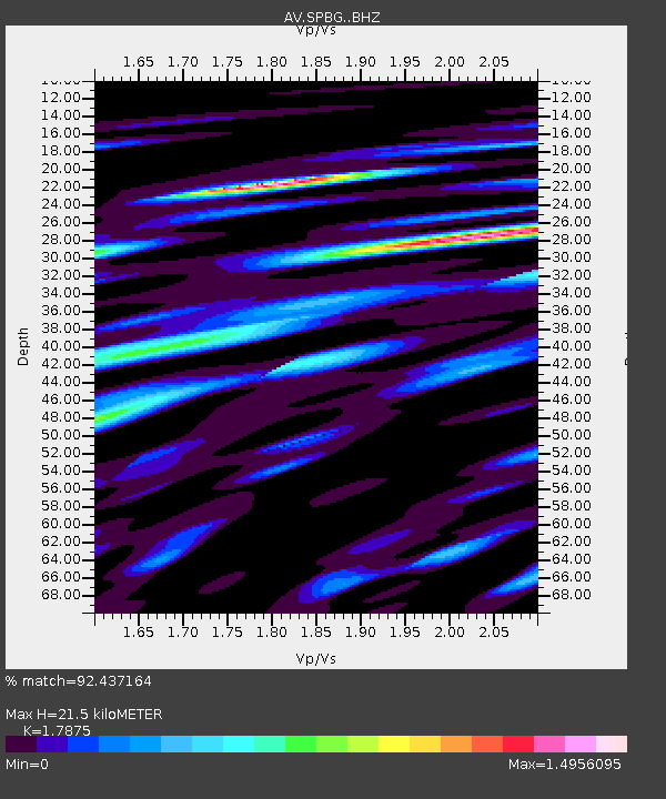
SPBG Barrier Glacier, Mount Spurr, Alaska - Earthquake Result Viewer
| Earthquake location: |
South Of Fiji Islands |
| Earthquake latitude/longitude: |
-23.0/-177.2 |
| Earthquake time(UTC): |
2023/06/15 (166) 18:06:27 GMT |
| Earthquake Depth: |
167 km |
| Earthquake Magnitude: |
7.2 Mww |
| Earthquake Catalog/Contributor: |
NEIC PDE/us |
|
| Network: |
AV Alaska Volcano Observatory |
| Station: |
SPBG Barrier Glacier, Mount Spurr, Alaska |
| Lat/Lon: |
61.26 N/152.37 W |
| Elevation: |
1087 m |
|
| Distance: |
86.3 deg |
| Az: |
11.737 deg |
| Baz: |
202.822 deg |
| Ray Param: |
0.04376233 |
| Estimated Moho Depth: |
21.5 km |
| Estimated Crust Vp/Vs: |
1.79 |
| Assumed Crust Vp: |
6.566 km/s |
| Estimated Crust Vs: |
3.673 km/s |
| Estimated Crust Poisson's Ratio: |
0.27 |
|
| Radial Match: |
92.437164 % |
| Radial Bump: |
400 |
| Transverse Match: |
86.96882 % |
| Transverse Bump: |
400 |
| SOD ConfigId: |
30536071 |
| Insert Time: |
2023-06-29 18:43:36.251 +0000 |
| GWidth: |
2.5 |
| Max Bumps: |
400 |
| Tol: |
0.001 |
|

Signal To Noise
| Channel | StoN | STA | LTA |
| AV:SPBG: :BHZ:20230615T18:18:19.580001Z | 155.24568 | 1.9146186E-5 | 1.2332829E-7 |
| AV:SPBG: :BHN:20230615T18:18:19.580001Z | 106.063446 | 1.3360028E-5 | 1.259626E-7 |
| AV:SPBG: :BHE:20230615T18:18:19.580001Z | 16.991837 | 5.185858E-6 | 3.0519703E-7 |
| Arrivals |
| Ps | 2.6 SECOND |
| PpPs | 8.9 SECOND |
| PsPs/PpSs | 12 SECOND |


