You are here: Home > Network List > AV - Alaska Volcano Observatory Stations List
> Station TANO North, Tanaga Volcano, Alaska > Earthquake Result Viewer
TANO North, Tanaga Volcano, Alaska - Earthquake Result Viewer
| Earthquake location: |
South Of Fiji Islands |
| Earthquake latitude/longitude: |
-23.0/-177.2 |
| Earthquake time(UTC): |
2023/06/15 (166) 18:06:27 GMT |
| Earthquake Depth: |
167 km |
| Earthquake Magnitude: |
7.2 Mww |
| Earthquake Catalog/Contributor: |
NEIC PDE/us |
|
| Network: |
AV Alaska Volcano Observatory |
| Station: |
TANO North, Tanaga Volcano, Alaska |
| Lat/Lon: |
51.91 N/178.12 W |
| Elevation: |
269 m |
|
| Distance: |
74.6 deg |
| Az: |
359.412 deg |
| Baz: |
179.125 deg |
| Ray Param: |
0.051815376 |
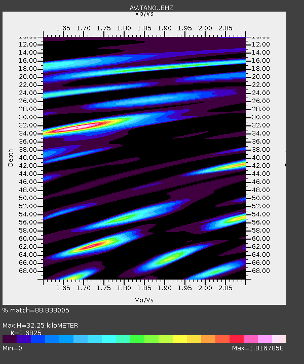
| Estimated Moho Depth: |
32.25 km |
| Estimated Crust Vp/Vs: |
1.68 |
| Assumed Crust Vp: |
6.048 km/s |
| Estimated Crust Vs: |
3.595 km/s |
| Estimated Crust Poisson's Ratio: |
0.23 |
|
| Radial Match: |
88.838005 % |
| Radial Bump: |
400 |
| Transverse Match: |
82.282074 % |
| Transverse Bump: |
400 |
| SOD ConfigId: |
30536071 |
| Insert Time: |
2023-06-29 18:43:53.212 +0000 |
| GWidth: |
2.5 |
| Max Bumps: |
400 |
| Tol: |
0.001 |
|
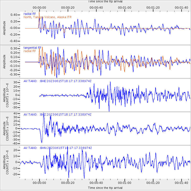
Signal To Noise
| Channel | StoN | STA | LTA |
| AV:TANO: :BHZ:20230615T18:17:17.338974Z | 24.64819 | 2.0039974E-5 | 8.1304046E-7 |
| AV:TANO: :BHN:20230615T18:17:17.338974Z | 6.7384067 | 7.5585167E-6 | 1.1217069E-6 |
| AV:TANO: :BHE:20230615T18:17:17.338974Z | 2.8987627 | 3.043595E-6 | 1.0499634E-6 |
| Arrivals |
| Ps | 3.8 SECOND |
| PpPs | 14 SECOND |
| PsPs/PpSs | 18 SECOND |


