You are here: Home > Network List > AV - Alaska Volcano Observatory Stations List
> Station TASE Southeast, Tanaga Volcano, Alaska > Earthquake Result Viewer
TASE Southeast, Tanaga Volcano, Alaska - Earthquake Result Viewer
| Earthquake location: |
South Of Fiji Islands |
| Earthquake latitude/longitude: |
-23.0/-177.2 |
| Earthquake time(UTC): |
2023/06/15 (166) 18:06:27 GMT |
| Earthquake Depth: |
167 km |
| Earthquake Magnitude: |
7.2 Mww |
| Earthquake Catalog/Contributor: |
NEIC PDE/us |
|
| Network: |
AV Alaska Volcano Observatory |
| Station: |
TASE Southeast, Tanaga Volcano, Alaska |
| Lat/Lon: |
51.83 N/178.04 W |
| Elevation: |
682 m |
|
| Distance: |
74.5 deg |
| Az: |
359.465 deg |
| Baz: |
179.205 deg |
| Ray Param: |
0.051869556 |
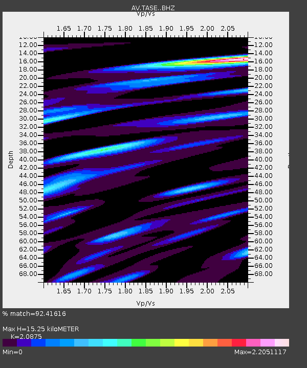
| Estimated Moho Depth: |
15.25 km |
| Estimated Crust Vp/Vs: |
2.09 |
| Assumed Crust Vp: |
6.048 km/s |
| Estimated Crust Vs: |
2.897 km/s |
| Estimated Crust Poisson's Ratio: |
0.35 |
|
| Radial Match: |
92.41616 % |
| Radial Bump: |
379 |
| Transverse Match: |
83.71206 % |
| Transverse Bump: |
400 |
| SOD ConfigId: |
30536071 |
| Insert Time: |
2023-06-29 18:43:56.423 +0000 |
| GWidth: |
2.5 |
| Max Bumps: |
400 |
| Tol: |
0.001 |
|

Signal To Noise
| Channel | StoN | STA | LTA |
| AV:TASE: :BHZ:20230615T18:17:16.879989Z | 55.47717 | 2.134398E-5 | 3.8473448E-7 |
| AV:TASE: :BHN:20230615T18:17:16.879989Z | 32.61913 | 1.5458207E-5 | 4.7390006E-7 |
| AV:TASE: :BHE:20230615T18:17:16.879989Z | 7.3102365 | 3.9068696E-6 | 5.344382E-7 |
| Arrivals |
| Ps | 2.8 SECOND |
| PpPs | 7.6 SECOND |
| PsPs/PpSs | 10 SECOND |


