You are here: Home > Network List > AV - Alaska Volcano Observatory Stations List
> Station WESP Westdahl Peak, Westdahl Peak, Alaska > Earthquake Result Viewer
WESP Westdahl Peak, Westdahl Peak, Alaska - Earthquake Result Viewer
| Earthquake location: |
South Of Fiji Islands |
| Earthquake latitude/longitude: |
-23.0/-177.2 |
| Earthquake time(UTC): |
2023/06/15 (166) 18:06:27 GMT |
| Earthquake Depth: |
167 km |
| Earthquake Magnitude: |
7.2 Mww |
| Earthquake Catalog/Contributor: |
NEIC PDE/us |
|
| Network: |
AV Alaska Volcano Observatory |
| Station: |
WESP Westdahl Peak, Westdahl Peak, Alaska |
| Lat/Lon: |
54.49 N/164.72 W |
| Elevation: |
937 m |
|
| Distance: |
77.9 deg |
| Az: |
7.411 deg |
| Baz: |
191.756 deg |
| Ray Param: |
0.04959269 |
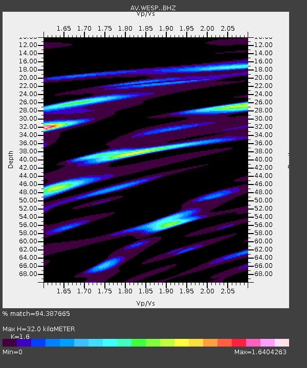
| Estimated Moho Depth: |
32.0 km |
| Estimated Crust Vp/Vs: |
1.60 |
| Assumed Crust Vp: |
5.989 km/s |
| Estimated Crust Vs: |
3.743 km/s |
| Estimated Crust Poisson's Ratio: |
0.18 |
|
| Radial Match: |
94.387665 % |
| Radial Bump: |
400 |
| Transverse Match: |
90.72607 % |
| Transverse Bump: |
400 |
| SOD ConfigId: |
30536071 |
| Insert Time: |
2023-06-29 18:44:15.423 +0000 |
| GWidth: |
2.5 |
| Max Bumps: |
400 |
| Tol: |
0.001 |
|

Signal To Noise
| Channel | StoN | STA | LTA |
| AV:WESP: :BHZ:20230615T18:17:36.019027Z | 22.79389 | 2.8217873E-5 | 1.2379578E-6 |
| AV:WESP: :BHN:20230615T18:17:36.019027Z | 17.621473 | 1.7045482E-5 | 9.673131E-7 |
| AV:WESP: :BHE:20230615T18:17:36.019027Z | 12.943114 | 1.4489367E-5 | 1.1194653E-6 |
| Arrivals |
| Ps | 3.3 SECOND |
| PpPs | 14 SECOND |
| PsPs/PpSs | 17 SECOND |


