You are here: Home > Network List > CI - Caltech Regional Seismic Network Stations List
> Station MPM Manuel Prospect Mine, California, USA > Earthquake Result Viewer
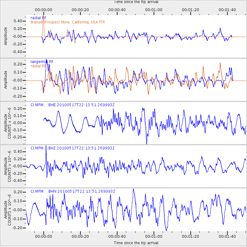
MPM Manuel Prospect Mine, California, USA - Earthquake Result Viewer
*The percent match for this event was below the threshold and hence no stack was calculated.
| Earthquake location: |
Kuril Islands |
| Earthquake latitude/longitude: |
46.3/152.0 |
| Earthquake time(UTC): |
2010/05/17 (137) 22:03:47 GMT |
| Earthquake Depth: |
73 km |
| Earthquake Magnitude: |
5.7 MB, 5.3 MW |
| Earthquake Catalog/Contributor: |
WHDF/NEIC |
|
| Network: |
CI Caltech Regional Seismic Network |
| Station: |
MPM Manuel Prospect Mine, California, USA |
| Lat/Lon: |
36.06 N/117.49 W |
| Elevation: |
185 m |
|
| Distance: |
65.3 deg |
| Az: |
63.081 deg |
| Baz: |
310.267 deg |
| Ray Param: |
$rayparam |
*The percent match for this event was below the threshold and hence was not used in the summary stack. |
|
| Radial Match: |
44.502045 % |
| Radial Bump: |
400 |
| Transverse Match: |
51.906315 % |
| Transverse Bump: |
400 |
| SOD ConfigId: |
314592 |
| Insert Time: |
2010-09-04 06:40:07.189 +0000 |
| GWidth: |
2.5 |
| Max Bumps: |
400 |
| Tol: |
0.001 |
|
Signal To Noise
| Channel | StoN | STA | LTA |
| CI:MPM: :BHZ:20100517T22:13:51.269993Z | 1.3692847 | 1.646333E-7 | 1.2023307E-7 |
| CI:MPM: :BHN:20100517T22:13:51.269993Z | 0.89701074 | 7.145598E-8 | 7.966011E-8 |
| CI:MPM: :BHE:20100517T22:13:51.269993Z | 0.8023769 | 6.543967E-8 | 8.1557275E-8 |
| Arrivals |
| Ps | |
| PpPs | |
| PsPs/PpSs | |


