You are here: Home > Network List > CC - Cascade Chain Volcano Monitoring Stations List
> Station TIMB Timberline, OR > Earthquake Result Viewer
TIMB Timberline, OR - Earthquake Result Viewer
| Earthquake location: |
South Of Fiji Islands |
| Earthquake latitude/longitude: |
-23.0/-177.2 |
| Earthquake time(UTC): |
2023/06/15 (166) 18:06:27 GMT |
| Earthquake Depth: |
167 km |
| Earthquake Magnitude: |
7.2 Mww |
| Earthquake Catalog/Contributor: |
NEIC PDE/us |
|
| Network: |
CC Cascade Chain Volcano Monitoring |
| Station: |
TIMB Timberline, OR |
| Lat/Lon: |
45.34 N/121.71 W |
| Elevation: |
1869 m |
|
| Distance: |
84.7 deg |
| Az: |
35.718 deg |
| Baz: |
229.708 deg |
| Ray Param: |
0.04493097 |
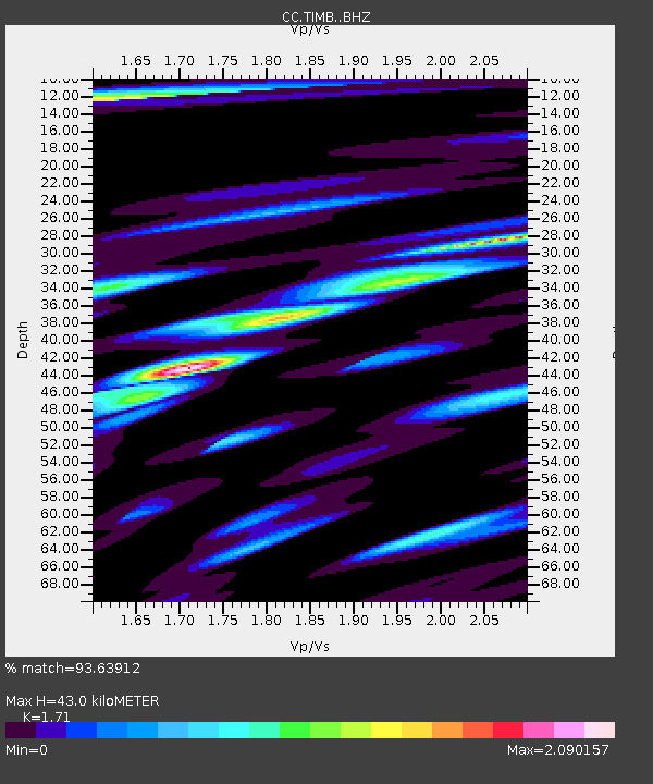
| Estimated Moho Depth: |
43.0 km |
| Estimated Crust Vp/Vs: |
1.71 |
| Assumed Crust Vp: |
6.597 km/s |
| Estimated Crust Vs: |
3.858 km/s |
| Estimated Crust Poisson's Ratio: |
0.24 |
|
| Radial Match: |
93.63912 % |
| Radial Bump: |
400 |
| Transverse Match: |
91.876114 % |
| Transverse Bump: |
400 |
| SOD ConfigId: |
30536071 |
| Insert Time: |
2023-06-29 18:47:36.786 +0000 |
| GWidth: |
2.5 |
| Max Bumps: |
400 |
| Tol: |
0.001 |
|

Signal To Noise
| Channel | StoN | STA | LTA |
| CC:TIMB: :BHZ:20230615T18:18:11.480026Z | 18.24763 | 4.2305237E-6 | 2.3183965E-7 |
| CC:TIMB: :BHN:20230615T18:18:11.480026Z | 5.788995 | 2.0329933E-6 | 3.5118242E-7 |
| CC:TIMB: :BHE:20230615T18:18:11.480026Z | 3.1718488 | 1.5325539E-6 | 4.831737E-7 |
| Arrivals |
| Ps | 4.8 SECOND |
| PpPs | 17 SECOND |
| PsPs/PpSs | 22 SECOND |


