You are here: Home > Network List > CI - Caltech Regional Seismic Network Stations List
> Station EDW2 EDW2, Mojave, CA, USA > Earthquake Result Viewer
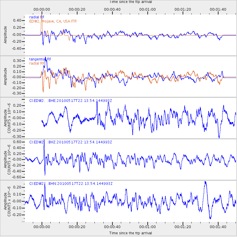
EDW2 EDW2, Mojave, CA, USA - Earthquake Result Viewer
*The percent match for this event was below the threshold and hence no stack was calculated.
| Earthquake location: |
Kuril Islands |
| Earthquake latitude/longitude: |
46.3/152.0 |
| Earthquake time(UTC): |
2010/05/17 (137) 22:03:47 GMT |
| Earthquake Depth: |
73 km |
| Earthquake Magnitude: |
5.7 MB, 5.3 MW |
| Earthquake Catalog/Contributor: |
WHDF/NEIC |
|
| Network: |
CI Caltech Regional Seismic Network |
| Station: |
EDW2 EDW2, Mojave, CA, USA |
| Lat/Lon: |
34.88 N/117.99 W |
| Elevation: |
772 m |
|
| Distance: |
65.8 deg |
| Az: |
64.356 deg |
| Baz: |
310.503 deg |
| Ray Param: |
$rayparam |
*The percent match for this event was below the threshold and hence was not used in the summary stack. |
|
| Radial Match: |
62.842407 % |
| Radial Bump: |
400 |
| Transverse Match: |
56.015137 % |
| Transverse Bump: |
400 |
| SOD ConfigId: |
314592 |
| Insert Time: |
2010-09-04 06:40:47.702 +0000 |
| GWidth: |
2.5 |
| Max Bumps: |
400 |
| Tol: |
0.001 |
|
Signal To Noise
| Channel | StoN | STA | LTA |
| CI:EDW2: :BHZ:20100517T22:13:54.144993Z | 2.2476776 | 2.0242982E-7 | 9.0061775E-8 |
| CI:EDW2: :BHN:20100517T22:13:54.144993Z | 1.2832471 | 8.274751E-8 | 6.448291E-8 |
| CI:EDW2: :BHE:20100517T22:13:54.144993Z | 1.0996207 | 8.918699E-8 | 8.110705E-8 |
| Arrivals |
| Ps | |
| PpPs | |
| PsPs/PpSs | |


