You are here: Home > Network List > CI - Caltech Regional Seismic Network Stations List
> Station TUQ Turquiose Mountain, Baker, CA, USA > Earthquake Result Viewer
TUQ Turquiose Mountain, Baker, CA, USA - Earthquake Result Viewer
| Earthquake location: |
South Of Fiji Islands |
| Earthquake latitude/longitude: |
-23.0/-177.2 |
| Earthquake time(UTC): |
2023/06/15 (166) 18:06:27 GMT |
| Earthquake Depth: |
167 km |
| Earthquake Magnitude: |
7.2 Mww |
| Earthquake Catalog/Contributor: |
NEIC PDE/us |
|
| Network: |
CI Caltech Regional Seismic Network |
| Station: |
TUQ Turquiose Mountain, Baker, CA, USA |
| Lat/Lon: |
35.44 N/115.92 W |
| Elevation: |
1350 m |
|
| Distance: |
82.1 deg |
| Az: |
46.305 deg |
| Baz: |
234.683 deg |
| Ray Param: |
0.04673266 |
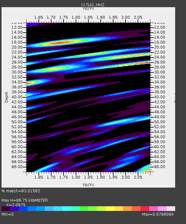
| Estimated Moho Depth: |
69.75 km |
| Estimated Crust Vp/Vs: |
2.10 |
| Assumed Crust Vp: |
6.276 km/s |
| Estimated Crust Vs: |
2.992 km/s |
| Estimated Crust Poisson's Ratio: |
0.35 |
|
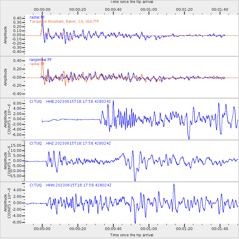
| Radial Match: |
93.01592 % |
| Radial Bump: |
400 |
| Transverse Match: |
90.717735 % |
| Transverse Bump: |
400 |
| SOD ConfigId: |
30536071 |
| Insert Time: |
2023-06-29 18:49:51.584 +0000 |
| GWidth: |
2.5 |
| Max Bumps: |
400 |
| Tol: |
0.001 |
|
Signal To Noise
| Channel | StoN | STA | LTA |
| CI:TUQ: :HHZ:20230615T18:17:58.428024Z | 37.982594 | 3.0546262E-6 | 8.042174E-8 |
| CI:TUQ: :HHN:20230615T18:17:58.428024Z | 4.4860826 | 6.8952534E-7 | 1.5370323E-7 |
| CI:TUQ: :HHE:20230615T18:17:58.428024Z | 4.243702 | 1.1681744E-6 | 2.752725E-7 |
| Arrivals |
| Ps | 12 SECOND |
| PpPs | 34 SECOND |
| PsPs/PpSs | 46 SECOND |


