You are here: Home > Network List > GS - US Geological Survey Networks Stations List
> Station ASA6 ASA6 > Earthquake Result Viewer
ASA6 ASA6 - Earthquake Result Viewer
| Earthquake location: |
South Of Fiji Islands |
| Earthquake latitude/longitude: |
-23.0/-177.2 |
| Earthquake time(UTC): |
2023/06/15 (166) 18:06:27 GMT |
| Earthquake Depth: |
167 km |
| Earthquake Magnitude: |
7.2 Mww |
| Earthquake Catalog/Contributor: |
NEIC PDE/us |
|
| Network: |
GS US Geological Survey Networks |
| Station: |
ASA6 ASA6 |
| Lat/Lon: |
34.94 N/106.46 W |
| Elevation: |
1840 m |
|
| Distance: |
88.4 deg |
| Az: |
50.886 deg |
| Baz: |
240.504 deg |
| Ray Param: |
0.042251565 |
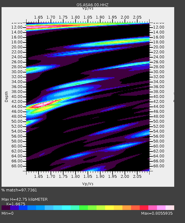
| Estimated Moho Depth: |
42.75 km |
| Estimated Crust Vp/Vs: |
1.67 |
| Assumed Crust Vp: |
6.502 km/s |
| Estimated Crust Vs: |
3.899 km/s |
| Estimated Crust Poisson's Ratio: |
0.22 |
|
| Radial Match: |
97.7361 % |
| Radial Bump: |
400 |
| Transverse Match: |
94.43087 % |
| Transverse Bump: |
400 |
| SOD ConfigId: |
30536071 |
| Insert Time: |
2023-06-29 18:53:02.745 +0000 |
| GWidth: |
2.5 |
| Max Bumps: |
400 |
| Tol: |
0.001 |
|

Signal To Noise
| Channel | StoN | STA | LTA |
| GS:ASA6:00:HHZ:20230615T18:18:29.468979Z | 29.880022 | 1.9801969E-6 | 6.62716E-8 |
| GS:ASA6:00:HH1:20230615T18:18:29.468979Z | 5.8082633 | 3.8138742E-7 | 6.56629E-8 |
| GS:ASA6:00:HH2:20230615T18:18:29.468979Z | 10.026041 | 5.1203915E-7 | 5.107092E-8 |
| Arrivals |
| Ps | 4.5 SECOND |
| PpPs | 17 SECOND |
| PsPs/PpSs | 22 SECOND |


