You are here: Home > Network List > IW - Intermountain West Stations List
> Station DLMT Dillon, Montana, USA > Earthquake Result Viewer
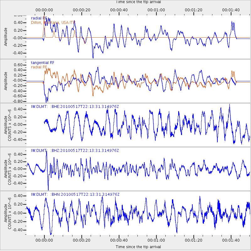
DLMT Dillon, Montana, USA - Earthquake Result Viewer
*The percent match for this event was below the threshold and hence no stack was calculated.
| Earthquake location: |
Kuril Islands |
| Earthquake latitude/longitude: |
46.3/152.0 |
| Earthquake time(UTC): |
2010/05/17 (137) 22:03:47 GMT |
| Earthquake Depth: |
73 km |
| Earthquake Magnitude: |
5.7 MB, 5.3 MW |
| Earthquake Catalog/Contributor: |
WHDF/NEIC |
|
| Network: |
IW Intermountain West |
| Station: |
DLMT Dillon, Montana, USA |
| Lat/Lon: |
45.36 N/112.60 W |
| Elevation: |
1569 m |
|
| Distance: |
62.3 deg |
| Az: |
52.453 deg |
| Baz: |
308.754 deg |
| Ray Param: |
$rayparam |
*The percent match for this event was below the threshold and hence was not used in the summary stack. |
|
| Radial Match: |
40.10461 % |
| Radial Bump: |
400 |
| Transverse Match: |
52.708252 % |
| Transverse Bump: |
400 |
| SOD ConfigId: |
314592 |
| Insert Time: |
2010-09-04 06:43:21.922 +0000 |
| GWidth: |
2.5 |
| Max Bumps: |
400 |
| Tol: |
0.001 |
|
Signal To Noise
| Channel | StoN | STA | LTA |
| IW:DLMT: :BHZ:20100517T22:13:31.314976Z | 2.3717716 | 2.1223293E-7 | 8.9482874E-8 |
| IW:DLMT: :BHN:20100517T22:13:31.314976Z | 2.0920377 | 2.815905E-7 | 1.3460107E-7 |
| IW:DLMT: :BHE:20100517T22:13:31.314976Z | 1.0790952 | 2.1699617E-7 | 2.0109084E-7 |
| Arrivals |
| Ps | |
| PpPs | |
| PsPs/PpSs | |


