You are here: Home > Network List > JP - Japan Meteorological Agency Seismic Network Stations List
> Station JGF Gifu Kurokawa > Earthquake Result Viewer
JGF Gifu Kurokawa - Earthquake Result Viewer
| Earthquake location: |
South Of Fiji Islands |
| Earthquake latitude/longitude: |
-23.0/-177.2 |
| Earthquake time(UTC): |
2023/06/15 (166) 18:06:27 GMT |
| Earthquake Depth: |
167 km |
| Earthquake Magnitude: |
7.2 Mww |
| Earthquake Catalog/Contributor: |
NEIC PDE/us |
|
| Network: |
JP Japan Meteorological Agency Seismic Network |
| Station: |
JGF Gifu Kurokawa |
| Lat/Lon: |
35.60 N/137.35 E |
| Elevation: |
580 m |
|
| Distance: |
72.4 deg |
| Az: |
322.48 deg |
| Baz: |
136.468 deg |
| Ray Param: |
0.053237453 |
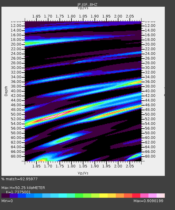
| Estimated Moho Depth: |
50.25 km |
| Estimated Crust Vp/Vs: |
1.74 |
| Assumed Crust Vp: |
6.461 km/s |
| Estimated Crust Vs: |
3.719 km/s |
| Estimated Crust Poisson's Ratio: |
0.25 |
|
| Radial Match: |
92.95977 % |
| Radial Bump: |
400 |
| Transverse Match: |
91.973885 % |
| Transverse Bump: |
400 |
| SOD ConfigId: |
30536071 |
| Insert Time: |
2023-06-29 18:55:14.293 +0000 |
| GWidth: |
2.5 |
| Max Bumps: |
400 |
| Tol: |
0.001 |
|

Signal To Noise
| Channel | StoN | STA | LTA |
| JP:JGF: :BHZ:20230615T18:17:04.850021Z | 35.678516 | 8.055964E-6 | 2.2579313E-7 |
| JP:JGF: :BHN:20230615T18:17:04.850021Z | 17.170448 | 2.3808004E-6 | 1.3865686E-7 |
| JP:JGF: :BHE:20230615T18:17:04.850021Z | 12.518173 | 2.1851113E-6 | 1.7455513E-7 |
| Arrivals |
| Ps | 5.9 SECOND |
| PpPs | 21 SECOND |
| PsPs/PpSs | 26 SECOND |


