You are here: Home > Network List > JP - Japan Meteorological Agency Seismic Network Stations List
> Station JOW Okinawa Kunigami > Earthquake Result Viewer
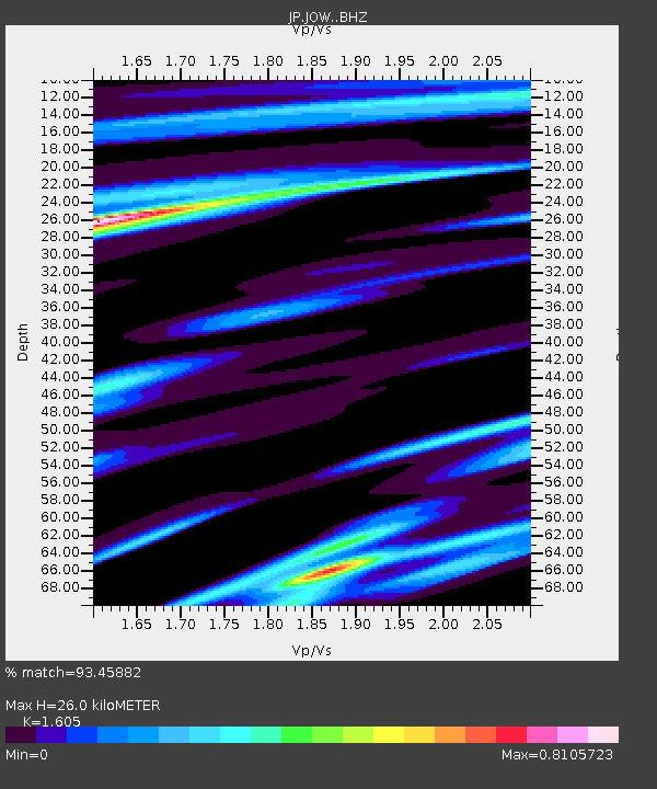
JOW Okinawa Kunigami - Earthquake Result Viewer
| Earthquake location: |
South Of Fiji Islands |
| Earthquake latitude/longitude: |
-23.0/-177.2 |
| Earthquake time(UTC): |
2023/06/15 (166) 18:06:27 GMT |
| Earthquake Depth: |
167 km |
| Earthquake Magnitude: |
7.2 Mww |
| Earthquake Catalog/Contributor: |
NEIC PDE/us |
|
| Network: |
JP Japan Meteorological Agency Seismic Network |
| Station: |
JOW Okinawa Kunigami |
| Lat/Lon: |
26.84 N/128.27 E |
| Elevation: |
220 m |
|
| Distance: |
72.3 deg |
| Az: |
310.212 deg |
| Baz: |
128.036 deg |
| Ray Param: |
0.053305175 |
| Estimated Moho Depth: |
26.0 km |
| Estimated Crust Vp/Vs: |
1.61 |
| Assumed Crust Vp: |
6.183 km/s |
| Estimated Crust Vs: |
3.852 km/s |
| Estimated Crust Poisson's Ratio: |
0.18 |
|
| Radial Match: |
93.45882 % |
| Radial Bump: |
331 |
| Transverse Match: |
88.43605 % |
| Transverse Bump: |
400 |
| SOD ConfigId: |
30536071 |
| Insert Time: |
2023-06-29 18:55:22.563 +0000 |
| GWidth: |
2.5 |
| Max Bumps: |
400 |
| Tol: |
0.001 |
|

Signal To Noise
| Channel | StoN | STA | LTA |
| JP:JOW: :BHZ:20230615T18:17:04.249984Z | 24.44398 | 1.2324246E-5 | 5.041833E-7 |
| JP:JOW: :BHN:20230615T18:17:04.249984Z | 5.695448 | 3.1235245E-6 | 5.4842474E-7 |
| JP:JOW: :BHE:20230615T18:17:04.249984Z | 8.490343 | 3.6826564E-6 | 4.337465E-7 |
| Arrivals |
| Ps | 2.6 SECOND |
| PpPs | 11 SECOND |
| PsPs/PpSs | 13 SECOND |


