You are here: Home > Network List > KN - Kyrgyz Seismic Telemetry Network Stations List
> Station TKM2 KN.TKM2 > Earthquake Result Viewer
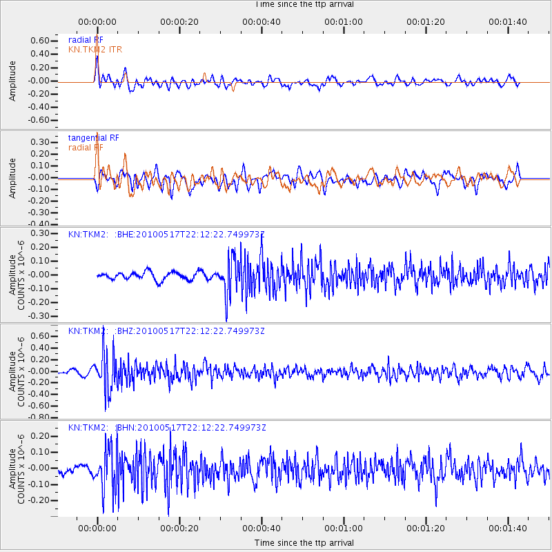
TKM2 KN.TKM2 - Earthquake Result Viewer
*The percent match for this event was below the threshold and hence no stack was calculated.
| Earthquake location: |
Kuril Islands |
| Earthquake latitude/longitude: |
46.3/152.0 |
| Earthquake time(UTC): |
2010/05/17 (137) 22:03:47 GMT |
| Earthquake Depth: |
73 km |
| Earthquake Magnitude: |
5.7 MB, 5.3 MW |
| Earthquake Catalog/Contributor: |
WHDF/NEIC |
|
| Network: |
KN Kyrgyz Seismic Telemetry Network |
| Station: |
TKM2 KN.TKM2 |
| Lat/Lon: |
42.92 N/75.60 E |
| Elevation: |
2020 m |
|
| Distance: |
52.5 deg |
| Az: |
295.868 deg |
| Baz: |
58.147 deg |
| Ray Param: |
$rayparam |
*The percent match for this event was below the threshold and hence was not used in the summary stack. |
|
| Radial Match: |
54.975544 % |
| Radial Bump: |
400 |
| Transverse Match: |
66.25056 % |
| Transverse Bump: |
400 |
| SOD ConfigId: |
314592 |
| Insert Time: |
2010-09-04 06:44:26.181 +0000 |
| GWidth: |
2.5 |
| Max Bumps: |
400 |
| Tol: |
0.001 |
|
Signal To Noise
| Channel | StoN | STA | LTA |
| KN:TKM2: :BHZ:20100517T22:12:22.749973Z | 11.854754 | 3.2682402E-7 | 2.7569024E-8 |
| KN:TKM2: :BHN:20100517T22:12:22.749973Z | 6.5102997 | 1.3261004E-7 | 2.0369269E-8 |
| KN:TKM2: :BHE:20100517T22:12:22.749973Z | 4.630108 | 1.3028182E-7 | 2.8137967E-8 |
| Arrivals |
| Ps | |
| PpPs | |
| PsPs/PpSs | |


