You are here: Home > Network List > NN - Western Great Basin/Eastern Sierra Nevada Stations List
> Station GWY Greenwater Valley, CA. (GPS 12/06/2000) w84gm > Earthquake Result Viewer
GWY Greenwater Valley, CA. (GPS 12/06/2000) w84gm - Earthquake Result Viewer
| Earthquake location: |
South Of Fiji Islands |
| Earthquake latitude/longitude: |
-23.0/-177.2 |
| Earthquake time(UTC): |
2023/06/15 (166) 18:06:27 GMT |
| Earthquake Depth: |
167 km |
| Earthquake Magnitude: |
7.2 Mww |
| Earthquake Catalog/Contributor: |
NEIC PDE/us |
|
| Network: |
NN Western Great Basin/Eastern Sierra Nevada |
| Station: |
GWY Greenwater Valley, CA. (GPS 12/06/2000) w84gm |
| Lat/Lon: |
36.19 N/116.67 W |
| Elevation: |
1538 m |
|
| Distance: |
82.0 deg |
| Az: |
45.334 deg |
| Baz: |
234.115 deg |
| Ray Param: |
0.046771217 |
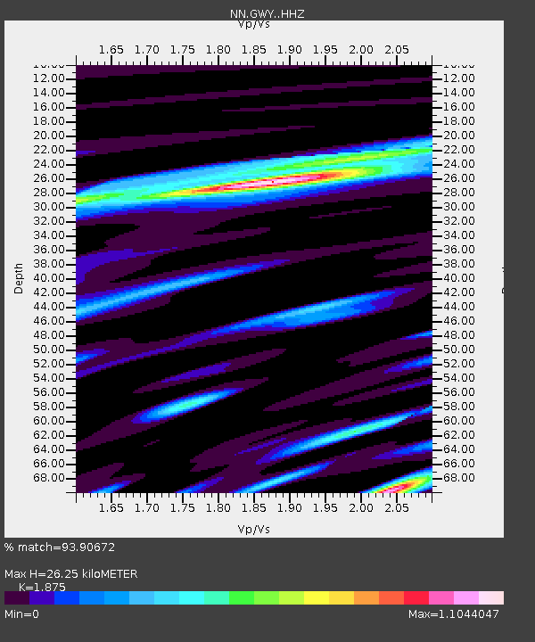
| Estimated Moho Depth: |
26.25 km |
| Estimated Crust Vp/Vs: |
1.88 |
| Assumed Crust Vp: |
6.279 km/s |
| Estimated Crust Vs: |
3.349 km/s |
| Estimated Crust Poisson's Ratio: |
0.30 |
|
| Radial Match: |
93.90672 % |
| Radial Bump: |
400 |
| Transverse Match: |
81.95992 % |
| Transverse Bump: |
400 |
| SOD ConfigId: |
30536071 |
| Insert Time: |
2023-06-29 18:57:03.134 +0000 |
| GWidth: |
2.5 |
| Max Bumps: |
400 |
| Tol: |
0.001 |
|

Signal To Noise
| Channel | StoN | STA | LTA |
| NN:GWY: :HHZ:20230615T18:17:58.127975Z | 34.068985 | 1.9986242E-6 | 5.8664032E-8 |
| NN:GWY: :HHN:20230615T18:17:58.127975Z | 3.0879164 | 5.6825667E-7 | 1.8402592E-7 |
| NN:GWY: :HHE:20230615T18:17:58.127975Z | 7.956871 | 8.7902157E-7 | 1.1047327E-7 |
| Arrivals |
| Ps | 3.7 SECOND |
| PpPs | 12 SECOND |
| PsPs/PpSs | 15 SECOND |


