You are here: Home > Network List > NN - Western Great Basin/Eastern Sierra Nevada Stations List
> Station TBRD Thunderbird Lodge, Lake Tahoe, NV > Earthquake Result Viewer
TBRD Thunderbird Lodge, Lake Tahoe, NV - Earthquake Result Viewer
| Earthquake location: |
South Of Fiji Islands |
| Earthquake latitude/longitude: |
-23.0/-177.2 |
| Earthquake time(UTC): |
2023/06/15 (166) 18:06:27 GMT |
| Earthquake Depth: |
167 km |
| Earthquake Magnitude: |
7.2 Mww |
| Earthquake Catalog/Contributor: |
NEIC PDE/us |
|
| Network: |
NN Western Great Basin/Eastern Sierra Nevada |
| Station: |
TBRD Thunderbird Lodge, Lake Tahoe, NV |
| Lat/Lon: |
39.17 N/119.93 W |
| Elevation: |
1952 m |
|
| Distance: |
81.8 deg |
| Az: |
41.356 deg |
| Baz: |
231.569 deg |
| Ray Param: |
0.04694946 |
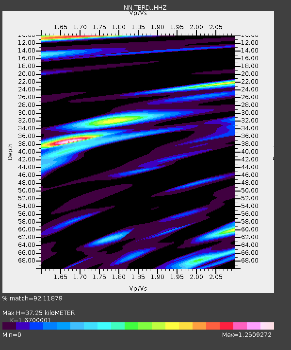
| Estimated Moho Depth: |
37.25 km |
| Estimated Crust Vp/Vs: |
1.67 |
| Assumed Crust Vp: |
6.279 km/s |
| Estimated Crust Vs: |
3.76 km/s |
| Estimated Crust Poisson's Ratio: |
0.22 |
|
| Radial Match: |
92.11879 % |
| Radial Bump: |
400 |
| Transverse Match: |
89.6682 % |
| Transverse Bump: |
400 |
| SOD ConfigId: |
30536071 |
| Insert Time: |
2023-06-29 18:57:30.164 +0000 |
| GWidth: |
2.5 |
| Max Bumps: |
400 |
| Tol: |
0.001 |
|

Signal To Noise
| Channel | StoN | STA | LTA |
| NN:TBRD: :HHZ:20230615T18:17:56.76799Z | 17.555744 | 2.9402215E-6 | 1.6747917E-7 |
| NN:TBRD: :HHN:20230615T18:17:56.76799Z | 1.4325616 | 5.3593755E-7 | 3.7411135E-7 |
| NN:TBRD: :HHE:20230615T18:17:56.76799Z | 2.6139565 | 5.917133E-7 | 2.2636691E-7 |
| Arrivals |
| Ps | 4.1 SECOND |
| PpPs | 15 SECOND |
| PsPs/PpSs | 20 SECOND |


