You are here: Home > Network List > O2 - Oklahoma Consolidated Temporary Seismic Networks Stations List
> Station MRSH Marshall, Oklahoma, USA > Earthquake Result Viewer
MRSH Marshall, Oklahoma, USA - Earthquake Result Viewer
| Earthquake location: |
South Of Fiji Islands |
| Earthquake latitude/longitude: |
-23.0/-177.2 |
| Earthquake time(UTC): |
2023/06/15 (166) 18:06:27 GMT |
| Earthquake Depth: |
167 km |
| Earthquake Magnitude: |
7.2 Mww |
| Earthquake Catalog/Contributor: |
NEIC PDE/us |
|
| Network: |
O2 Oklahoma Consolidated Temporary Seismic Networks |
| Station: |
MRSH Marshall, Oklahoma, USA |
| Lat/Lon: |
36.13 N/97.70 W |
| Elevation: |
309 m |
|
| Distance: |
95.3 deg |
| Az: |
53.074 deg |
| Baz: |
245.51 deg |
| Ray Param: |
0.040702943 |
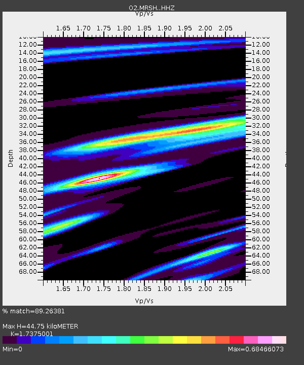
| Estimated Moho Depth: |
44.75 km |
| Estimated Crust Vp/Vs: |
1.74 |
| Assumed Crust Vp: |
6.483 km/s |
| Estimated Crust Vs: |
3.731 km/s |
| Estimated Crust Poisson's Ratio: |
0.25 |
|
| Radial Match: |
89.26381 % |
| Radial Bump: |
400 |
| Transverse Match: |
71.490326 % |
| Transverse Bump: |
400 |
| SOD ConfigId: |
30536071 |
| Insert Time: |
2023-06-29 18:58:47.054 +0000 |
| GWidth: |
2.5 |
| Max Bumps: |
400 |
| Tol: |
0.001 |
|

Signal To Noise
| Channel | StoN | STA | LTA |
| O2:MRSH: :HHZ:20230615T18:19:01.194992Z | 11.806251 | 8.794864E-7 | 7.449328E-8 |
| O2:MRSH: :HHN:20230615T18:19:01.194992Z | 1.049835 | 1.7897226E-7 | 1.7047657E-7 |
| O2:MRSH: :HHE:20230615T18:19:01.194992Z | 2.038646 | 3.4772512E-7 | 1.7056671E-7 |
| Arrivals |
| Ps | 5.2 SECOND |
| PpPs | 19 SECOND |
| PsPs/PpSs | 24 SECOND |


