You are here: Home > Network List > O2 - Oklahoma Consolidated Temporary Seismic Networks Stations List
> Station PW07 Ralston, Oklahoma, USA > Earthquake Result Viewer
PW07 Ralston, Oklahoma, USA - Earthquake Result Viewer
| Earthquake location: |
South Of Fiji Islands |
| Earthquake latitude/longitude: |
-23.0/-177.2 |
| Earthquake time(UTC): |
2023/06/15 (166) 18:06:27 GMT |
| Earthquake Depth: |
167 km |
| Earthquake Magnitude: |
7.2 Mww |
| Earthquake Catalog/Contributor: |
NEIC PDE/us |
|
| Network: |
O2 Oklahoma Consolidated Temporary Seismic Networks |
| Station: |
PW07 Ralston, Oklahoma, USA |
| Lat/Lon: |
36.50 N/96.77 W |
| Elevation: |
282 m |
|
| Distance: |
96.1 deg |
| Az: |
53.044 deg |
| Baz: |
246.062 deg |
| Ray Param: |
0.04046718 |
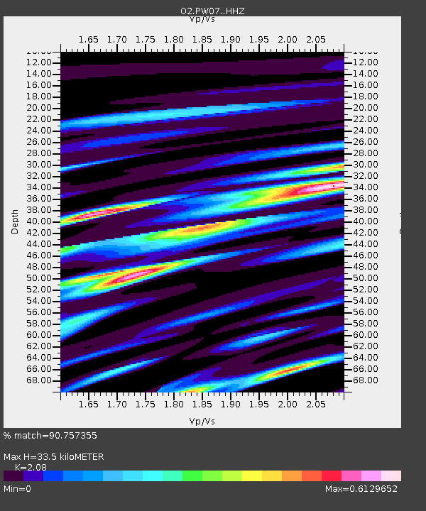
| Estimated Moho Depth: |
33.5 km |
| Estimated Crust Vp/Vs: |
2.08 |
| Assumed Crust Vp: |
6.483 km/s |
| Estimated Crust Vs: |
3.117 km/s |
| Estimated Crust Poisson's Ratio: |
0.35 |
|
| Radial Match: |
90.757355 % |
| Radial Bump: |
400 |
| Transverse Match: |
78.383446 % |
| Transverse Bump: |
400 |
| SOD ConfigId: |
30536071 |
| Insert Time: |
2023-06-29 18:58:57.165 +0000 |
| GWidth: |
2.5 |
| Max Bumps: |
400 |
| Tol: |
0.001 |
|

Signal To Noise
| Channel | StoN | STA | LTA |
| O2:PW07: :HHZ:20230615T18:19:04.965011Z | 7.9251266 | 6.786912E-7 | 8.563791E-8 |
| O2:PW07: :HHN:20230615T18:19:04.965011Z | 0.82636356 | 9.41388E-8 | 1.1391935E-7 |
| O2:PW07: :HHE:20230615T18:19:04.965011Z | 1.1930199 | 2.5420255E-7 | 2.1307484E-7 |
| Arrivals |
| Ps | 5.7 SECOND |
| PpPs | 16 SECOND |
| PsPs/PpSs | 21 SECOND |


